October 28, 2025, was a very bad day to be in Jamaica. That morning, Category 5 Hurricane Melissa intensified into the strongest hurricane ever observed in the Atlantic: 190 mph (305 km/h) winds, a tie with Hurricane Allen of 1980. That afternoon Melissa powered ashore in Jamaica, causing a catastrophic $8.8 billion in damage, equivalent to 41% of Jamaica’s GDP.
Melissa came close to its maximum potential intensity
The maximum potential intensity of a tropical cyclone is the maximum strength a storm can achieve based on the existing atmospheric and oceanic conditions. Potential intensity theory was pioneered in 1987 by MIT hurricane scientist Kerry Emanuel, who showed that human-caused global warming will increase the maximum strength that a hurricane can achieve. Hurricanes are heat engines that take heat energy out of the ocean and convert it to the kinetic energy of wind, so it makes sense that the winds of the strongest hurricanes will get stronger as the oceans heat up.
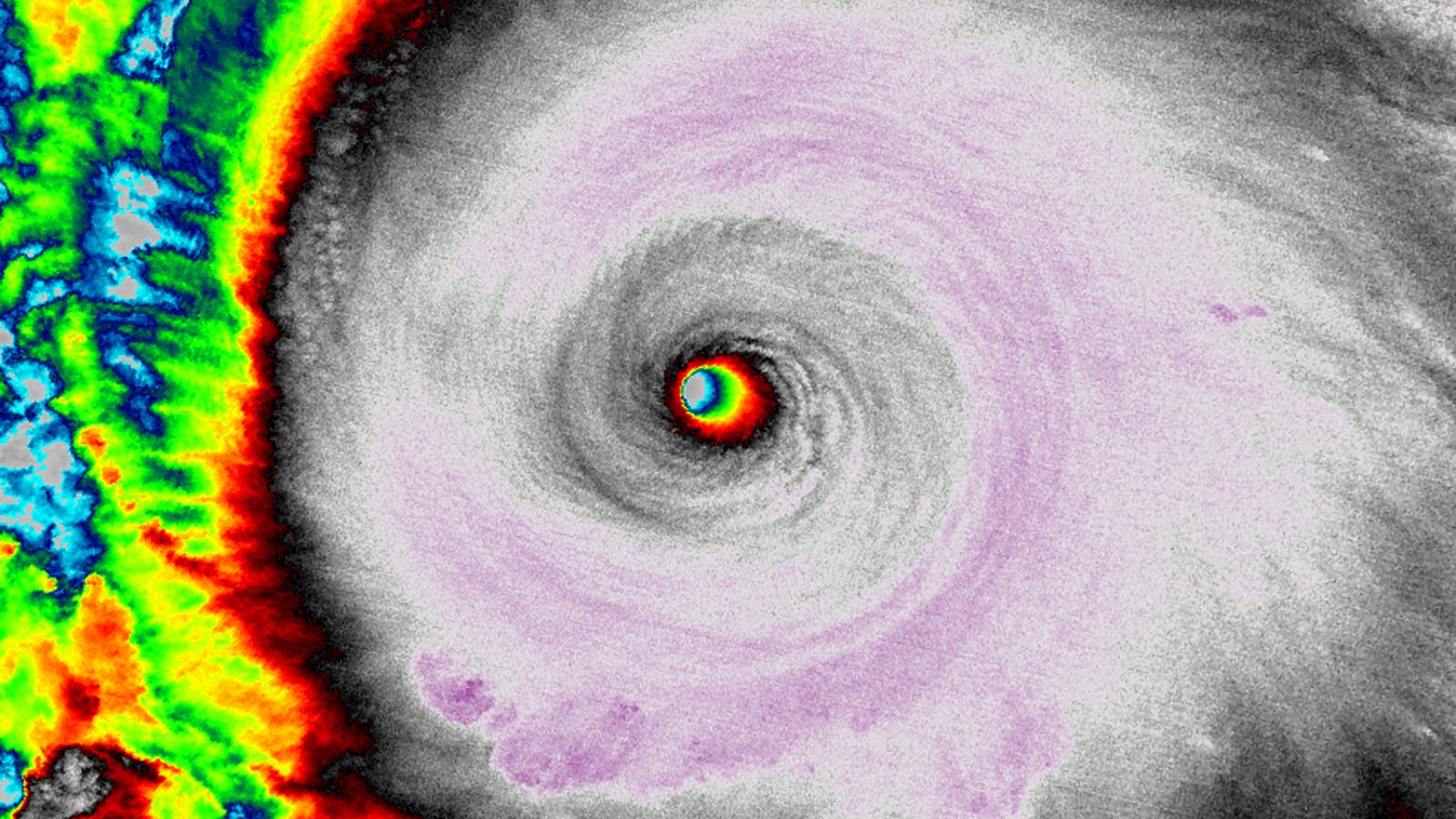
Melissa’s 190-mph winds were very close to its maximum potential intensity: The hurricane’s maximum potential intensity was about 197 mph (317 km/h), according to the SHIPS model, and about 200 mph (320 km/h), according to a graphic available at the University of Wisconsin’s CIMSS (Fig. 1). It is quite rare for a hurricane to come this close to its maximum potential intensity — all conditions have to be perfect, and the atmosphere and ocean make up a complex system where perfection is rarely achieved.

Given the less-than-ideal conditions for intensification – light to moderate wind shear of 5-15 knots, a very slow forward speed of less than 5 mph that allowed upwelling of cooler water from the depths to affect it, and interaction with the rugged terrain of Jamaica – Melissa came remarkably close to its maximum potential intensity. (The formula for maximum potential intensity does not include wind shear and slow hurricane motion.)
So how strong could Melissa have gotten if everything were going its way? Melissa formed in late October, when ocean temperatures were about 30 degrees Celsius (86°F). Six weeks earlier, during the early- to mid- September peak of sea surface temperatures, ocean temperatures in the central Caribbean were near 31 degrees Celsius (88°F). According to a 2023 paper, the maximum potential intensity increases 5-7% per degree Celsius of sea surface temperature increase. Thus, Melissa’s maximum potential intensity would have increased by about 11-15 mph (18-25 km/h) had it formed during the September peak in sea surface temperatures. If we assume the other factors limiting its intensification were not present, Melissa could have peaked with 215 mph (345 km/h) winds.
This is the same intensity achieved by the strongest known hurricane in world history, 2015’s Hurricane Patricia. Patricia formed off the Pacific coast of Mexico over record-warm waters of 30.5-31 degrees Celsius (87-88°F). And though the difference between 180 mph and 215 mph may not seem like much, it would actually represent about a fourfold increase in damage potential, according to NOAA.

How strong can a hurricane get?
The global list of tropical cyclones during the satellite era (1972-present) with winds as strong or stronger than Melissa is a short one: just 11 storms (Fig. 2). (There were 19 Western Pacific typhoons from 1955-1966 that “officially” have winds of 195 mph or higher, but hurricane experts agree that the intensities assigned to typhoons during that pre-satellite period suffered from a high bias and are not reliable.)
For most of the Northern Hemisphere’s tropical cyclone-prone areas, September will be the month with the highest possible maximum potential intensity, since that is when sea surface temperatures peak. Emanuel, the MIT hurricane scientist, created maps of the top 10% maximum potential intensity expected within 1,000 km of a given point during September, using climate data from the period 1982-1995 (Fig. 3). In the Atlantic, the Gulf of Mexico and western Caribbean have the highest values: 224 mph (100 m/s) or higher. In the Pacific, the southern Philippines, Mexico, and most of Central America also have a top 10% maximum potential intensity of 224 mph (100 m/s) or higher.

Emanuel also created a table showing the top-10% maximum potential intensities for individual cities across the globe. All of these numbers (and the ones in Fig. 3) need to be adjusted upward because the climate has warmed significantly since the 1995 cutoff of the historical data used. A 2022 paper, A potential explanation for the global increase in tropical cyclone rapid intensification, reported that between 1982 and 2017, potential intensity during August-September-October in the Northern Hemisphere tropics increased by 2.3-2.4 mph per decade, or 8.6 mph over the 36-year period (1.02-1.06 m/s per decade). During that same period, Northern Hemisphere tropical sea surface temperatures increased by 0.17-0.23 degree Celsius per decade, or 0.6-0.8 degree Celsius over the 36-year period. A 2021 paper, Poleward expansion of tropical cyclone latitudes, reported similar numbers, with larger increases in potential intensity observed in the eastern Caribbean and western Gulf of Mexico.
These results suggest that the maximum potential intensity numbers in Fig. 3 and in Emanuel’s table should be adjusted upward by about 9 mph (4 m/s). Here are the adjusted numbers for the U.S. from Emanuel’s table showing the top-10% maximum potential intensities for individual cities:
Boston: 78 mph (35 m/s), Cat 1
Honolulu: 186 mph (84 m/s), Cat 5
Miami: 226 mph (101 m/s), Cat 5
Galveston: 220 mph (98 m/s), Cat 5
New Orleans: 231 mph (103 m/s), Cat 5
New York City: 112 mph (50 m/s), Cat 2
San Diego: 72 mph (32 m/s), Tropical Storm
Washington D.C.: 105 mph (47 m/s), Cat 2
Note that for cities like Boston and Washington, D.C., fast-moving storms coming from the south – where they typically move over warmer waters – can arrive at these cities at a strength higher than the local maximum potential intensity. This is why there is a separate entry in Emanuel’s table for the highest maximum potential intensity within 1,000 km of each city. I didn’t show this quantity in the list above, though it is plotted in Fig. 3.
A 300-mph (134 m/s) tropical cyclone is possible in the Persian Gulf
Globally, the highest maximum potential intensities are found in the ultrahot waters of the Middle East. There has never been a tropical cyclone observed in the Persian Gulf because it is narrow and prone to high wind shear and dry air.

However, for their eye-popping 2015 paper, Grey swan tropical cyclones, Ning Lin and Kerry Emanuel performed modeling showing that strong tropical cyclones can move through the Persian Gulf, representing an underappreciated threat to major cities like Dubai. The modeling showed that a sea surface temperature of 35 degrees Celsius (95°F) can create a maximum potential intensity of 296 mph (132 m/s) in the Persian Gulf. Their worst-case 1-in-30,000-year storm was a 257 mph (115 m/s) Category 5 beast with a central pressure of 784 mb that brought a colossal storm surge of 24 feet (7.5 meters) to Dubai.
The study used the climate of 1980-2010, and sea surface temperatures in the Persian Gulf have warmed significantly since then. Over the period 1981-2012, the Persian Gulf had peak summer sea surface temperatures of 32-35 degrees Celsius (90-95°F). But in July 2020, those temperatures hit 37.6 degrees Celsius (99.7°F). More recently, in August 2023, sea surface temperatures above 36 degrees Celsius (97°F) were measured over portions of the Persian Gulf. Thus, an even stronger storm – with winds over 300 mph (134 m/s) – would be possible in today’s climate.
There has been a recent close call for a strong tropical cyclone entering the Persian Gulf: In 2021, Category 1 Tropical Cyclone Gulab (Fig. 4) entered the Gulf of Oman, which connects to the Persian Gulf. A four-day forecast from the HWRF model (Fig. 5) predicted Gulab would pass over Dubai in the United Arab Emirates, enter the Persian Gulf, and then intensify into a Category 2 storm with a central pressure of 958 mb. Fortunately, Gulab ended up weakening into a tropical storm and making landfall in Oman, near the entrance to the Persian Gulf.

Sources of real-time maximum potential intensity data
Kerry Emanuel’s website
University of Wisconsin CIMSS (for active storms)
SHIPS model (for active storms)
Our other posts in this series
Bob Henson contributed to this post.
![]()
Source link