| Mesoscale Discussion 101 | |
| < Previous MD | |

|
|
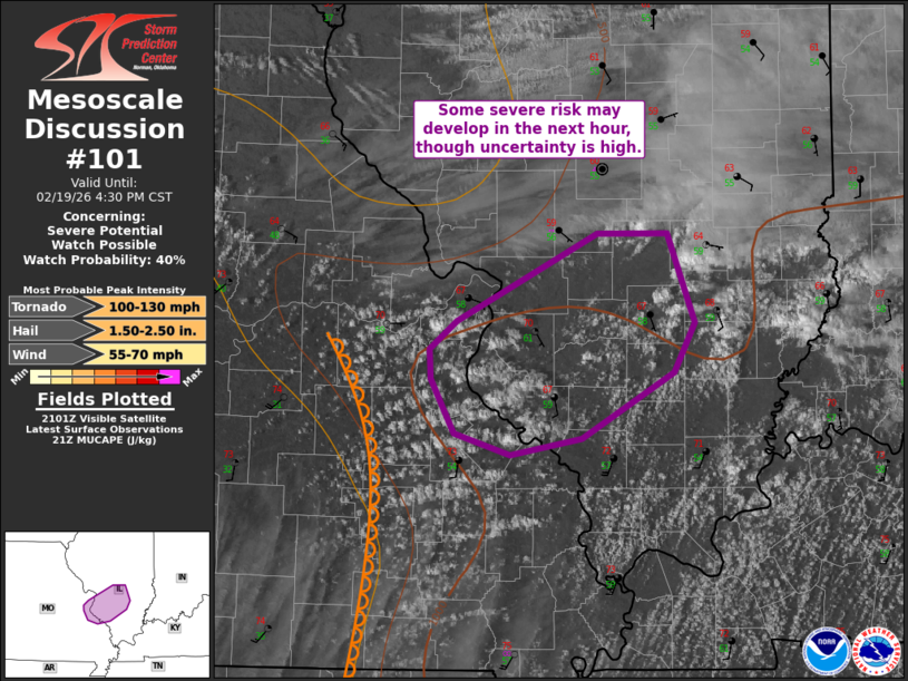
Mesoscale Discussion 0101 NWS Storm Prediction Center Norman OK 0306 PM CST Thu Feb 19 2026 Areas affected...far east-central MO into southwest/west-central IL Concerning...Severe potential...Watch possible Valid 192106Z - 192230Z Probability of Watch Issuance...40 percent SUMMARY...Isolated thunderstorms may develop over the next hour, though confidence in development is low. If a storm can develop, large hail and possibly a tornado could occur. Monitoring convective trends for possible watch issuance. DISCUSSION...Agitated cumulus has been noted in visible satellite imagery this afternoon across east-central MO toward the MS River. This activity is occurring ahead of a surging surface dryline within the modestly moist warm sector. Large-scale ascent is increasing across the region, and low to midlevel flow is likewise becoming more favorable for organized convection. However, the thermodynamic environment remains lackluster given shallow/modest boundary layer moisture with dewpoints generally in the mid to upper 50s F. However, if a storm can develop, steep midlevel lapse rates and supercell wind profiles will support large hail. As the surface low over northeast MO continues eastward, low-level SRH also will increase. If a storm can develop and mature, at least some tornado risk could accompany this activity. Given uncertainty, it is unclear of a small severe or tornado watch will be needed before any developing convection moves east into WW 0010. ..Leitman/Mosier.. 02/19/2026 ...Please see www.spc.noaa.gov for graphic product... ATTN...WFO...PAH...ILX...LSX... LAT...LON 38609045 39148937 39148883 38608862 38308877 37908949 37809004 37939047 38259064 38439066 38609045 MOST PROBABLE PEAK TORNADO INTENSITY...100-130 MPH MOST PROBABLE PEAK WIND GUST...55-70 MPH MOST PROBABLE PEAK HAIL SIZE...1.50-2.50 IN |
|
|
Top/All Mesoscale Discussions/Forecast Products/Home |
|
Source link