| Mesoscale Discussion 76 | |
| < Previous MD | |

|
|
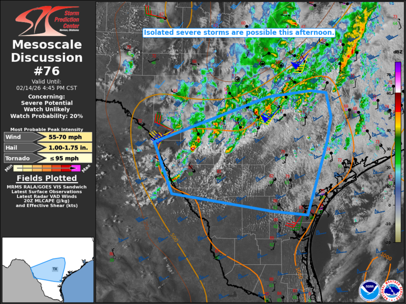
   Mesoscale Discussion 0076
   NWS Storm Prediction Center Norman OK
   0248 PM CST Sat Feb 14 2026

   Areas affected...Parts of south-central TX

   Concerning...Severe potential...Watch unlikely

   Valid 142048Z - 142245Z

   Probability of Watch Issuance...20 percent

   SUMMARY...Isolated severe storms are possible this afternoon.

   DISCUSSION...A discrete cell has recently intensified across
   Maverick and Zavala Counties, while other more disorganized storms
   continue to develop near/north of a sagging outflow in the San
   Antonio vicinity. The undercutting outflow has tended to limit storm
   duration and intensity thus far, but the Zavala County cell may have
   a somewhat better opportunity to persist as it moves nearly parallel
   to the outflow over the next 1-2 hours. Additional isolated cells
   may develop later this afternoon across parts of south-central TX,
   as relatively strong heating and ascent attendant to an approaching
   mid/upper-level shortwave trough continue to erode an initially
   substantial capping inversion.

   MLCAPE of near/above 1000 J/kg and strong deep-layer shear are
   conditionally supportive of organized convection, and some threat
   for severe hail and wind may accompany any persistent cells through
   the afternoon. At this time, the severe threat is expected to remain
   rather isolated, with the southeastward-moving outflow potentially
   limiting the duration of any discrete cells. Uncertainty regarding
   the coverage of the threat renders watch issuance unlikely, though
   trends will continue to be monitored for development of multiple
   longer-lived cells.

   ..Dean/Gleason.. 02/14/2026

   ...Please see www.spc.noaa.gov for graphic product...

   ATTN...WFO...CRP...EWX...

   LAT...LON   29040067 29919824 30029733 29979701 29529690 29079699
               27709743 27779815 28080027 29040067

   MOST PROBABLE PEAK TORNADO INTENSITY...UP TO 95 MPH
   MOST PROBABLE PEAK WIND GUST...55-70 MPH
   MOST PROBABLE PEAK HAIL SIZE...1.00-1.75 IN
|
|
|
Top/All Mesoscale Discussions/Forecast Products/Home |
|
Source link