| Mesoscale Discussion 71 | |
| < Previous MD | |

|
|
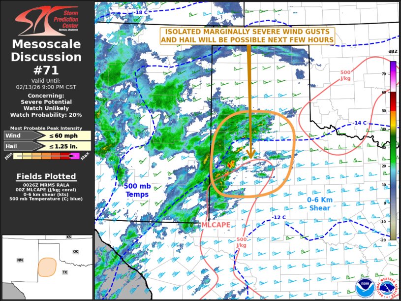
   Mesoscale Discussion 0071
   NWS Storm Prediction Center Norman OK
   0628 PM CST Fri Feb 13 2026

   Areas affected...West Texas

   Concerning...Severe potential...Watch unlikely

   Valid 140028Z - 140300Z

   Probability of Watch Issuance...20 percent

   SUMMARY...A marginal threat for severe gusts and hail may develop
   across parts of west Texas this evening. The threat is expected too
   be to isolated for watch issuance.

   DISCUSSION...A subtle shortwave trough is evident on water vapor
   imagery over west Texas. Ahead of this feature, scattered
   thunderstorms have developed over the last couple of hours to the
   north and west of Lubbock. In the vicinity of these storms,
   mesoscale analysis shows a small pocket of instability in west Texas
   with SBCAPE near 1000 J/kg. In addition, the Lubbock WSR-88D VWP has
   0-6 km shear in the 75 to 80 knot range, with some speed shear in
   the mid-levels. This could support weak rotation within the stronger
   cells. RAP forecast soundings have 700-500 mb lapse rates near 7
   C/km, which could be enough for isolated marginally severe hail. A
   strong wind gust would also be possible. However, the weak
   instability will be a limiting factor, and any severe threat should
   remain very isolated through mid to late evening.

   ..Broyles/Hart.. 02/14/2026

   ...Please see www.spc.noaa.gov for graphic product...

   ATTN...WFO...LUB...AMA...MAF...

   LAT...LON   33530301 34150293 34530270 34740234 34820190 34780110
               34550064 34140050 33340064 32940092 32750127 32670175
               32680226 32700261 32840285 33130300 33530301

   MOST PROBABLE PEAK WIND GUST...UP TO 60 MPH
   MOST PROBABLE PEAK HAIL SIZE...UP TO 1.25 IN
|
|
|
Top/All Mesoscale Discussions/Forecast Products/Home |
|
Source link