| Mesoscale Discussion 69 | |
| < Previous MD | |
|
|
Mesoscale Discussion 0069
NWS Storm Prediction Center Norman OK
0520 PM CST Sat Jan 31 2026
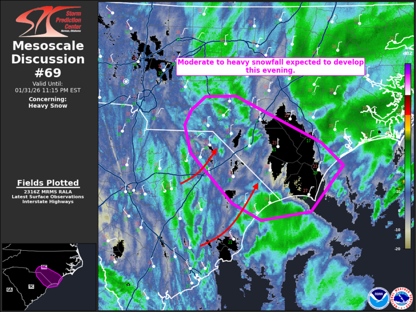
Areas affected...Northeast South Carolina into southeast North
Carolina
Concerning...Heavy snow
Valid 312320Z - 010415Z
CORRECTED FOR AREAS AFFECTED TYPO
SUMMARY...A focused corridor of mid-level ascent and a favorable
thermodynamic profile will promote moderate to heavy snowfall
potential along the NC/SC border this evening.
DISCUSSION...A loosely organized band of snowfall is evident on KCAE
radar imagery. This feature is tied to a shortwave trough moving
through the southern Appalachians. This trough is expected to peak
in intensity and become more negatively tilted around midnight to 1
AM EST. This will lead to a more consolidated and deepening coastal
low off the coast of the Carolinas. Cooling of the atmospheric
profile at mid-levels will foster a deeper layer within the
dendritic growth zone and the band of snowfall should become more
organized with time. Moderate to heavy snowfall rates (up to around
an inch per hour) will be possible near the SC/NC border this
evening.
..Wendt.. 01/31/2026
...Please see www.spc.noaa.gov for graphic product...
ATTN...WFO...MHX...RAH...ILM...CAE...
LAT...LON 33567886 33807934 34508005 34638008 34898014 35098003
35297979 35297929 34647784 34327747 33697803 33567886
|
|
|
Top/All Mesoscale Discussions/Forecast Products/Home |
|
Source link