| Mesoscale Discussion 51 | |
| < Previous MD | |

|
|
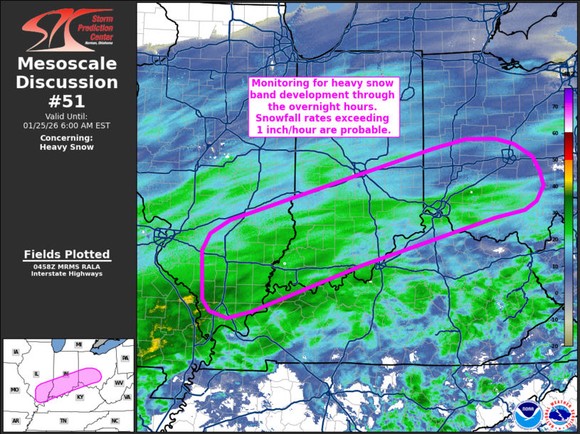
   Mesoscale Discussion 0051
   NWS Storm Prediction Center Norman OK
   1100 PM CST Sat Jan 24 2026

   Areas affected...Southern Illinois into southern Indiana and
   southwest Ohio

   Concerning...Heavy snow

   Valid 250500Z - 251100Z

   SUMMARY...Heavy snow band development is anticipated through the
   next several hours across portions of the Ohio River Valley.
   Snowfall rates exceeding 1 inch/hour appear probable later tonight.

   DISCUSSION...A broad band of heavier precipitation is beginning to
   emerge from northern AR into the lower OH Valley per regional radar
   mosaics over the past 1-2 hours. This comes amid strengthening
   frontogenesis through a deep layer (925-700 mb per recent
   mesoanalyses) as the primary upper wave begins to migrate eastward
   into the southern Plains. Latest forecast guidance shows
   intensifying frontogenesis across the lower MS Valley into the OH
   Valley through 09-12 UTC, which will support further
   organization/intensification of a focused mesoscale precipitation
   band. With mid-level temperatures below freezing north of the OH
   River, snow should remain the predominant precipitation type.
   Moderate snowfall rates will be common with a focused corridor of
   higher rates (in excess of 1 inch/hour) likely. Per recent ensemble
   guidance, this corridor will most likely emerge across southern IL
   into southern IN and southwest OH.

   These solutions also depict optimal banding potential during the
   09-12 UTC period later tonight into early Sunday morning. However,
   recent ASOS/AWOS observations from southern IL and southern IN have
   shown an uptick in snowfall intensity (denoted by reduced
   visibilities to 1/2 mile or less) over the past hour. These trends
   suggest that the onset of heavier snowfall rates may commence
   earlier than currently anticipated by most guidance as intermittent
   moderate to heavy snow bands becomes more prominent with time.

   ..Moore.. 01/25/2026

   ...Please see www.spc.noaa.gov for graphic product...

   ATTN...WFO...RLX...ILN...LMK...IND...PAH...ILX...LSX...

   LAT...LON   39118269 39008330 38248609 37788746 37478836 37358887
               37458924 37648940 38458944 38728928 38968886 40158461
               40308388 40298326 40208288 39988248 39738234 39498228
               39248243 39118269
|
|
|
Top/All Mesoscale Discussions/Forecast Products/Home |
|
Source link