| Mesoscale Discussion 49 | |
| < Previous MD | |

|
|
Mesoscale Discussion 0049
NWS Storm Prediction Center Norman OK
0746 PM CST Sat Jan 24 2026
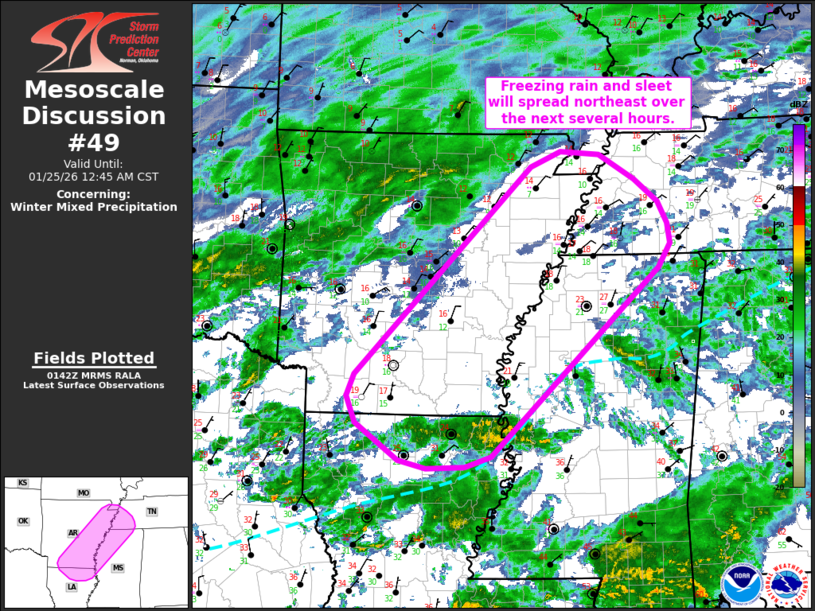
Areas affected...Northern Louisiana into eastern
Arkansas...northwest Mississippi...and far western Tennessee
Concerning...Winter mixed precipitation
Valid 250146Z - 250645Z
SUMMARY...Another round of freezing rain and sleet is expected to
spread out of northern Louisiana into eastern Arkansas and northwest
Mississippi. Freezing rain rates upwards of 0.05 inch/hour appear
likely for some locations.
DISCUSSION...Recent radar mosaics show a developing plume of
precipitation across central to northern LA - likely associated with
strengthening warm advection between 925-850 mb. Over the next
several hours, an uptick in low-level winds should promote further
augmentation of isentropic and frontogenetical ascent across the
lower MS River Valley. Regional 00z RAOBs from SHV and LZK sampled a
stout (4-12 C) warm layer between 850-700 mb that will melt
hydrometeors as precipitation spreads north/northeast. Sub-freezing
surface temperatures will promote some degree of re-freezing near
the surface, though locations with temperatures at or near/below 15
F will likely be sufficiently cold (and have a sufficiently deep
sub-freezing layer) to promote sleet as the predominant
precipitation type. Warmer locations will likely observe freezing
rain (with freezing rain rates up to 0.05 inch/hour) with periods of
sleet possible. Based on latest surface observations, freezing rain
appears most probable across southeast AR into northwest MS with
sleet more likely for locations further north into east-central AR
and far western TN.
..Moore.. 01/25/2026
...Please see www.spc.noaa.gov for graphic product...
ATTN...WFO...MEG...JAN...LZK...SHV...
LAT...LON 32499131 32369169 32359227 32459267 32909332 33239345
33509334 36089071 36279027 36238969 35928916 35648881
35388867 35128863 34838881 32499131
|
|
|
Top/All Mesoscale Discussions/Forecast Products/Home |
|
Source link