| Mesoscale Discussion 47 | |
| < Previous MD | |

|
|
Mesoscale Discussion 0047
NWS Storm Prediction Center Norman OK
0545 PM CST Sat Jan 24 2026
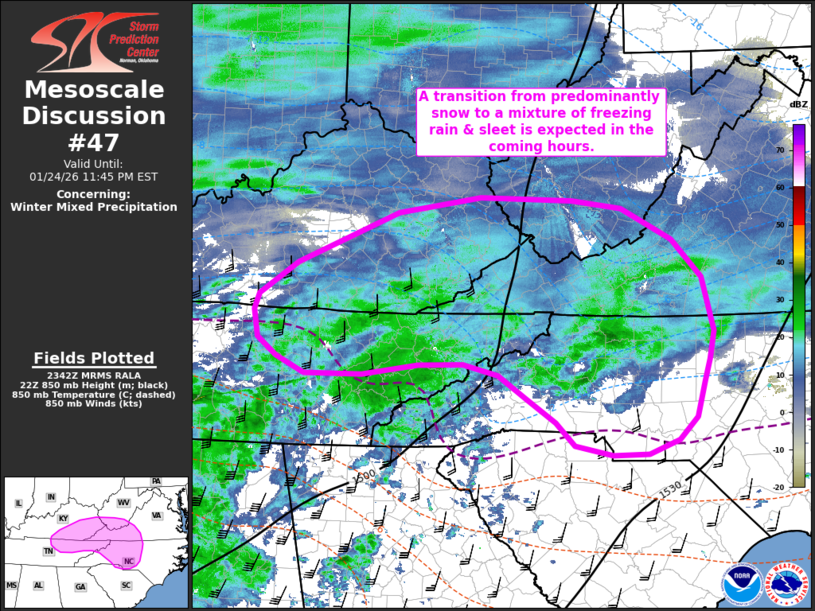
Areas affected...Portions of the southern Appalachians
Concerning...Winter mixed precipitation
Valid 242345Z - 250445Z
SUMMARY...A wintry mix of sleet and freezing rain is expected to
slowly spread north and east over the next 3-5 hours across portions
of the southern Appalachians. Areas currently observing snow will
likely see a transition to sleet/freezing rain during this period.
Freezing rain rates of 0.05 to 0.1 inch/hour appear possible.
DISCUSSION...Recent RAP/HRRR solutions appear to be capturing
ongoing precipitation-type trends well per latest ASOS/AWOS
observations and mPING reports. Surface observations also depict a
trough axis extending from southwest AL into the southern
Appalachians where surface pressure falls on the order of
approximately 1 mb/hour have been noted since 18 UTC. As broad-scale
ascent continues to increase with the gradual approach of the upper
wave to the west, further intensification of the surface trough
across the Southeast and lee of the southern Appalachians is
expected with a slight augmentation of southerly low-level winds and
warm air advection. This will shift the low-level freezing line
northward over the next several hours, resulting in a transition
from predominantly snow to a mixture of freezing rain and sleet (and
potentially to rain if surface temperatures can sufficiently warm).
Additionally, as low-level ascent spreads east/northeast, freezing
rain/sleet should become more widespread across portions of the
western Carolinas and into parts of VA - especially as low-level
saturation is achieved later this evening. Latest forecast guidance
continues to suggest that freezing rain rates upwards of 0.05 to 0.1
inch/hour will be possible.
..Moore.. 01/24/2026
...Please see www.spc.noaa.gov for graphic product...
ATTN...WFO...RAH...RNK...RLX...CAE...GSP...MRX...JKL...LMK...
OHX...
LAT...LON 35968364 35848447 35848534 36048575 36278604 36598610
36788603 37178545 37808395 37998272 37958136 37858062
37467986 37017942 36367926 36017933 35767940 35337952
35067980 34888025 34878078 34998133 35288162 35578206
35858246 35988299 35968364
|
|
|
Top/All Mesoscale Discussions/Forecast Products/Home |
|
Source link