| Mesoscale Discussion 44 | |
| < Previous MD | |
|
|
Mesoscale Discussion 0044
NWS Storm Prediction Center Norman OK
1034 AM CST Sat Jan 24 2026
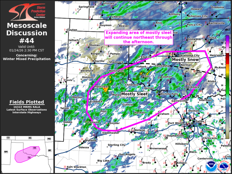
Areas affected...Portions of West Texas into central Oklahoma
Concerning...Winter mixed precipitation
Valid 241634Z - 242030Z
SUMMARY...An expanding area of mostly sleet will continue northeast
through the afternoon.
DISCUSSION...An area of showery precipitation continues to expand
from West Texas into southwest Oklahoma this morning. The
precipitation coverage is already more expansive than shown by any
12Z guidance and it continues to expand. This area of showers is
mostly sleet thus far, but KTLX CC and the 12Z OUN RAOB would imply
it will become mostly snow as it approaches I-40 across central
Oklahoma.
Sleet accumulation of 0.1 to 0.2 inches per hour and snowfall
accumulation of 0.5 to 1 inch per hour are possible within the
heavier showers/bands from Northwest Texas into central Oklahoma
through mid-afternoon.
Expect this area of precipitation to weaken as it moves farther
northeast during the afternoon. This will likely result in more
scattered precipitation coverage across this region for a few hours
during the late afternoon before precipitation rapidly expands this
evening ahead of the approaching main trough.
..Bentley.. 01/24/2026
...Please see www.spc.noaa.gov for graphic product...
ATTN...WFO...TSA...FWD...OUN...SJT...LUB...AMA...MAF...
LAT...LON 32490119 32610154 33220201 34030195 34640135 35719819
35709619 35059591 33939704 32969906 32480056 32490119
|
|
|
Top/All Mesoscale Discussions/Forecast Products/Home |
|
Source link