| Mesoscale Discussion 40 | |
| < Previous MD | |

|
|
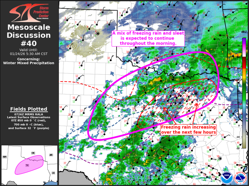
   Mesoscale Discussion 0040
   NWS Storm Prediction Center Norman OK
   0129 AM CST Sat Jan 24 2026

   Areas affected...Northwest/Southwest/North-Central
   TX...South-Central/Southeast OK

   Concerning...Winter mixed precipitation

   Valid 240729Z - 241130Z

   SUMMARY...A mix of freezing rain and sleet is expected to persist
   from southwest Texas into north-central Texas and
   south-central/southeast Oklahoma throughout the morning.

   DISCUSSION...Surface observations around the region currently place
   the freezing line from Bonham (in Fannin County TX) southwestward
   through northwest Tarrant County before diving more
   south-southwestward through San Saba, TX. This orientation puts much
   of the DFW Metroplex just above freezing, with some temperatures
   actually increasing a degree or two amid light precipitation and
   resultant wet bulbing. Even so, continued cold-air advection is
   anticipated, with temperatures eventually dropping below freezing
   later this morning. Those areas already below freezing will also see
   temperatures continue to decrease throughout the morning.

   Current regional radar imagery shows some banding across
   north-central TX (northwest of the Metroplex), where strong 850mb
   warm-air advection is ongoing. Correlation coefficient from KFWS
   suggests most of this is sleet. Additionally, a large area of light
   precipitation continues to build upstream of the region amid modest
   lift attendant to a subtle lead shortwave trough and continued
   isentropic ascent. Expectation is for precipitation to continue
   across this region for the next several hours, with sleet as the
   prominent p-type across southwest/northwest TX and south-central OK.
   Freezing rain will likely become more common across north-central TX
   over the next hour or two, with another transition to sleet possible
   later this morning as the surface continues to cool.

   ..Mosier.. 01/24/2026

   ...Please see www.spc.noaa.gov for graphic product...

   ATTN...WFO...SHV...TSA...FWD...OUN...SJT...LUB...MAF...

   LAT...LON   33530002 34539740 34689541 33419497 32439587 31120069
               32130113 33530002
|
|
|
Top/All Mesoscale Discussions/Forecast Products/Home |
|
Source link