| Mesoscale Discussion 39 | |
| < Previous MD Next MD > | |

|
|
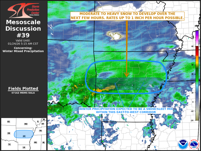
   Mesoscale Discussion 0039
   NWS Storm Prediction Center Norman OK
   0118 AM CST Sat Jan 24 2026

   Areas affected...Far Eastern Oklahoma...Central and Northern
   Arkansas.

   Concerning...Winter mixed precipitation

   Valid 240718Z - 241115Z

   SUMMARY...Heavy snowfall, with rates up to 1 inch per hour, are
   expected to develop from parts of far eastern Oklahoma eastward
   across much of central and northern Arkansas over the next several
   hours. The snow should be mixed with sleet over parts of central
   Arkansas.

   DISCUSSION...The latest water vapor imagery shows a mid-level trough
   in the western U.S., with a belt of strong zonal westerly flow over
   much of the central and eastern U.S. Lift is currently maximized
   over the Ark-La-Tex and southern Ozarks, where a shortwave trough
   appears to moving through the flow, and the right exit region of an
   expansive mid-level jet is located. Within this zone, radar shows a
   large area winter precipitation, which is organized into an
   east-to-west band. This band is being supported by strong lift
   associated with the northern edge of a 35 to 45 knot low-level jet.
   As the low-level jet shifts eastward across south-central Arkansas
   over the next 3 to 6 hours, isentropic lift will become maximized in
   parts of central and northern Arkansas. Snowfall rates are expected
   to peak near 1 inch per hour within the heaviest part of the band.
   On southern edge of the band, a sleet/snow mix is expected. The
   potential for heavy precipitation should continue over the next four
   to six hours.

   ..Broyles/Mosier.. 01/24/2026

   ...Please see www.spc.noaa.gov for graphic product...

   ATTN...WFO...MEG...LZK...SHV...TSA...

   LAT...LON   35809038 35429017 35139019 34919024 34569051 34479078
               34429160 34439365 34489446 34619484 34899502 35169505
               35579494 35969445 36069279 35989086 35809038
|
|
|
Top/All Mesoscale Discussions/Forecast Products/Home |
|
Source link