| Mesoscale Discussion 35 | |
| < Previous MD | |

|
|
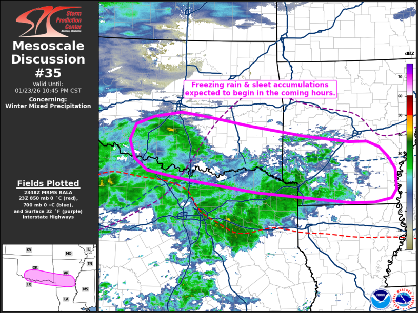
   Mesoscale Discussion 0035
   NWS Storm Prediction Center Norman OK
   0550 PM CST Fri Jan 23 2026

   Areas affected...Southern Oklahoma into far northern Texas and
   southern Arkansas

   Concerning...Winter mixed precipitation

   Valid 232350Z - 240445Z

   SUMMARY...Freezing rain and sleet accumulations are beginning across
   portions of southern Oklahoma, and are expected to spread east over
   the next several hours into northern/northeast Texas and southern
   Arkansas as precipitation increases across the region. Freezing rain
   rates up to 0.05 inch/hour appear likely along the Red River into
   southern Arkansas.

   DISCUSSION...Regional radar mosaics depict two plumes of moderate
   precipitation with notable bright banding across western TX into
   southern OK and from central TX into the Texarkana region. These
   plumes are largely being driven by a combination of deep isentropic
   upglide over a southward surging frontal zone and a frontogenetic
   response between 925-850 mb. The forcing mechanisms are expected to
   gradually shift east through late evening, which will likely result
   in a prolonged period of precipitation along the Red River into
   southern AR.

   At the surface, mPING reports of sleet in Lawton, OK hint that
   temperatures aloft (especially at around 700 mb) are likely warmer
   than depicted by recent mesoanalyses and RAP forecast soundings
   (implying a cold bias aloft). Recent HRRR solutions appear to be
   better resolving the placement and magnitude of the warm nose aloft
   (especially when compared with the recent 00z OUN sounding), and
   suggest that freezing rain should be the predominant precipitation
   type along/south of the Red River with increasing sleet amounts
   further north into OK. Although temperatures across southeast OK and
   southern AR remain above freezing as of 23:45 UTC, temperature falls
   on the order of 2-3 F/hour are noted in ASOS/OK Mesonet
   observations, so sub-freezing temperatures are expected within the
   next 1-3 hours as precipitation overspreads the region.

   Given these trends and recent model consensus, freezing rain rates
   up to 0.05 inch/hour appear likely along the Red River and into
   southern AR through 06 UTC. Sleet should be the primary
   precipitation type with northward extent into OK with moderate to
   heavy sleet accumulations probable. Given the weak (0.6 C) warm nose
   at 739 mb in the recent OUN sounding, a transition zone from sleet
   to moderate/heavy snow will likely manifest in the coming hours
   roughly along the I-40 corridor as precipitation spreads northeast.

   ..Moore.. 01/23/2026

   ...Please see www.spc.noaa.gov for graphic product...

   ATTN...WFO...JAN...LZK...SHV...TSA...FWD...OUN...

   LAT...LON   33339522 33569687 33699763 33839838 34129876 34569891
               34949874 35149821 35259743 35199689 35099625 34949540
               34699379 34539253 34539201 34409166 34159140 33859121
               33369118 33159133 33059183 33069250 33339522
|
|
|
Top/All Mesoscale Discussions/Forecast Products/Home |
|
Source link