| Mesoscale Discussion 26 | |
| < Previous MD | |

|
|
Mesoscale Discussion 0026
NWS Storm Prediction Center Norman OK
0606 AM CST Sun Jan 18 2026
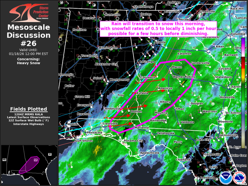
Areas affected...Portions of far southeast AL and the western FL
Panhandle into southwest and central GA
Concerning...Heavy snow
Valid 181206Z - 181700Z
SUMMARY...Rain will transition to snow this morning, with snowfall
rates around 0.5 to locally 1 inch per hour possible for a few hours
before diminishing.
DISCUSSION...A secondary surface cold front will continue to advance
southeastward across AL, GA, and the FL Panhandle this morning. A
plume of precipitation is ongoing ahead of/near the front across
southern/southeast AL into much of southern/central GA and parts of
the FL Panhandle. This activity is being aided by large-scale ascent
associated with an embedded mid-level shortwave trough moving
eastward across the Southeast and the entrance region of a
pronounced southwesterly mid/upper-level jet. Recent RAP/NAM
forecast soundings suggest that additional modest low/mid-level
cooling of already saturated profile will support a quick rain to
snow transition this morning across parts of southeast AL into
southwest/central GA and the FL Panhandle.
Latest (12Z) surface observations show this transition already
occurring across southeast AL, west-central GA, and the western FL
Panhandle, where temperatures have fallen into the low to mid 30s.
Expect this trend to continue farther east in southwest/central GA
through the remainder of the morning. While snowfall rates are not
forecast to be overly high, most guidance suggests that 0.5 to
locally 1 inch per hour rates may occur within the most intense
portion of the precipitation band. These enhanced snowfall rates
should not last more than a few hours in any given location, as
rapidly drying low/mid-levels on the back side of the shortwave
trough will quickly erode precipitation from west to east through
about 17Z (11 AM CST/Noon EST).
..Gleason.. 01/18/2026
...Please see www.spc.noaa.gov for graphic product...
ATTN...WFO...FFC...TAE...BMX...
LAT...LON 30938620 32248492 33078410 33188303 32838259 32218282
31528361 31058440 30698525 30518585 30658622 30938620
|
|
|
Top/All Mesoscale Discussions/Forecast Products/Home |
|
Source link