| Mesoscale Discussion 16 | |
| < Previous MD | |

|
|
   Mesoscale Discussion 0016
   NWS Storm Prediction Center Norman OK
   0640 PM CST Fri Jan 09 2026

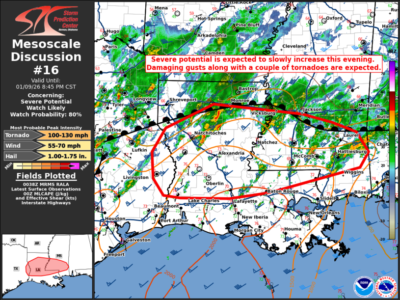
   Areas affected...portions of eastern Texas...Louisiana...and
   southern Mississippi

   Concerning...Severe potential...Watch likely

   Valid 100040Z - 100245Z

   Probability of Watch Issuance...80 percent

   SUMMARY...A gradual increase in storm intensity is expected this
   evening and tonight over portions of the Sabine and lower MS
   Valleys. A mix of supercells and linear segments will likely support
   a risk for damaging gusts and a couple tornadoes. One or more
   watches are likely in the next hour or two.

   DISCUSSION...As of 0130 UTC, regional radar and mesoanalysis showed
   scattered convection ongoing within a very moist and broad warm
   sector from east TX into LA and across southern MS. Over the last 2
   hours, convection within this region has slowly intensified as a
   positive-tilt upper trough over the southern Plains has moved
   eastward. Continued ascent and convective development within the
   warm sector appears likely this evening given robust moisture and
   buoyancy (MLCAPE 1000-2000 J/kg LIX/LCH RAOBs) with little to no
   inhibition remaining.

   Overall forcing is still somewhat nebulous and driven primarily by
   low-level warm advection. This suggests storm evolution is likely to
   be slow until the upper trough moves closer. Initial storm evolution
   is expected along low-level confluence structures and the cold front
   over eastern TX. Deep-layer shear (50-60 kt) oriented largely
   parallel to these features is favorable for storm organization, but
   with a mixed convective mode of supercells and linear segments. This
   will favor a risk for damaging gusts given strong mid and low-level
   flow.

   While initially somewhat weaker, low-level flow/shear should
   increase this evening as large-scale ascent from the approaching
   upper trough and nocturnal low-level jet intensify across LA and MS.
   Peak SRH (0-500m) of 100-150 m2/s2 will support low-level rotation
   and the potential for a couple tornadoes as well. This appears
   especially likely along the diffuse warm front where weak pressure
   falls are occurring and low-level winds are backed.

   Observational trends and short-term model guidance suggest
   convection will gradually increase in coverage and intensity this
   evening. As storms mature a severe threat should evolve and
   transition northeastward tonight. Given the potential for damaging
   gusts and a couple tornadoes, one or more watches is likely needed
   in the next hour or two.

   ..Lyons/Gleason.. 01/10/2026

   ...Please see www.spc.noaa.gov for graphic product...

   ATTN...WFO...MOB...JAN...LIX...LCH...SHV...

   LAT...LON   30409384 30789411 31389416 31939382 32509255 32269018
               32078938 31848874 31378844 31028868 30509099 30479125
               30369211 30369339 30409384

   MOST PROBABLE PEAK TORNADO INTENSITY...100-130 MPH
   MOST PROBABLE PEAK WIND GUST...55-70 MPH
   MOST PROBABLE PEAK HAIL SIZE...1.00-1.75 IN
|
|
|
Top/All Mesoscale Discussions/Forecast Products/Home |
|
Source link


