| Mesoscale Discussion 8 | |
| < Previous MD | |

|
|
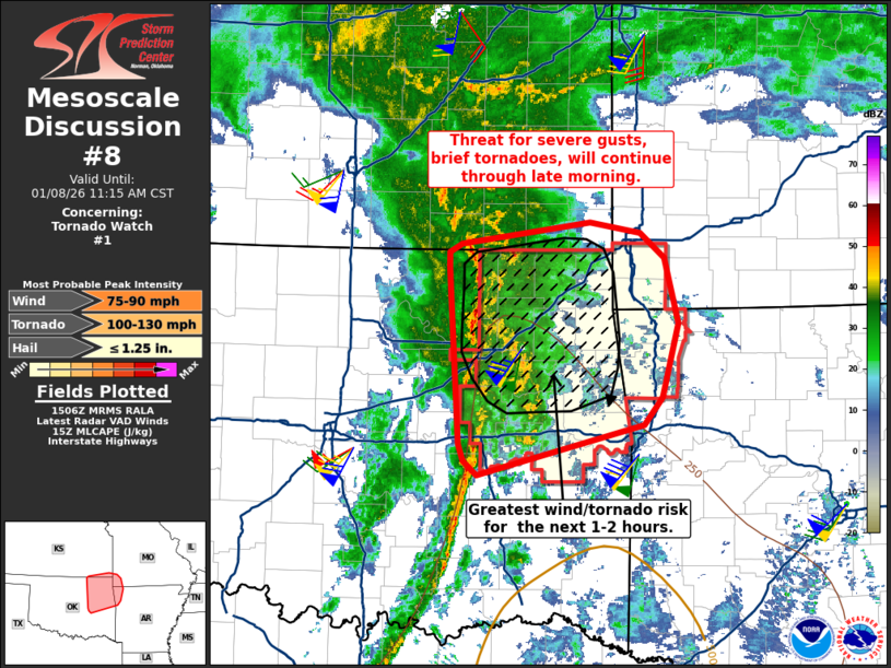
Mesoscale Discussion 0008 NWS Storm Prediction Center Norman OK 0908 AM CST Thu Jan 08 2026 Areas affected...Northeast Oklahoma into adjacent portions of Missouri and Arkansas Concerning...Tornado Watch 1... Valid 081508Z - 081715Z The severe weather threat for Tornado Watch 1 continues. SUMMARY...The threat for severe wind gusts and brief tornadoes will continue into the late morning hours for northeast Oklahoma and adjacent portions of Missouri and Arkansas. DISCUSSION...VWP observations from KINX in northeast OK depict a steady increase in low-level flow up to 50-60 knots within the 0-2 km AGL layer over the past 90 minutes. This is enlarging low-level hodographs with 0-1 km SRH increasing upwards of 400 m2/s2 immediately preceding developing warm-advection-driven convection and the more established squall line coming out of central OK. Similarly, the KTLX VWP in central OK is sampling the passage of a 75-80 knot mid-level jet that is supporting not only intense deep-layer wind shear but also strong ascent over northeast OK. These strong kinematics should compensate for an otherwise meager thermodynamic environment (250-500 J/kg MLCAPE) and will continue to support the potential for brief tornadoes as well as severe wind gusts. In the short term, the greatest severe wind/tornado threat will likely be associated with the more organized portion of the squall line (currently in Osage/Washington counties, OK) as it moves east/northeast over the next couple of hours. The loosely organized convection to the southeast of the Tulsa metro will likely undergo further organization with an increasing wind/tornado threat within the next couple of hours as a convective band becomes established. ..Moore.. 01/08/2026 ...Please see www.spc.noaa.gov for graphic product... ATTN...WFO...SGF...TSA...ICT...OUN... LAT...LON 35539430 35119601 35229615 35369621 36699629 36849631 36989631 37049618 37229484 37149432 36939407 36379393 35759410 35539430 MOST PROBABLE PEAK TORNADO INTENSITY...100-130 MPH MOST PROBABLE PEAK WIND GUST...75-90 MPH MOST PROBABLE PEAK HAIL SIZE...UP TO 1.25 IN |
|
|
Top/All Mesoscale Discussions/Forecast Products/Home |
|
Source link


