| Mesoscale Discussion 2 | |
| < Previous MD | |

|
|
Mesoscale Discussion 0002
NWS Storm Prediction Center Norman OK
0200 AM CST Thu Jan 01 2026
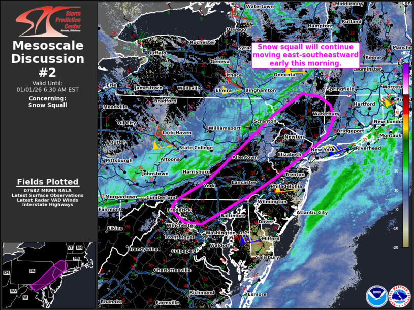
Areas affected...Northern Mid-Atlantic into the Hudson Valley
Concerning...Snow Squall
Valid 010800Z - 011130Z
SUMMARY...A snow squall currently over central/eastern Pennsylvania
will continue east-southeastward across the northern Mid-Atlantic
early this morning.
DISCUSSION...Radar data from KCCX and KBGM show a
northeast/southwest-oriented snow squall moving southeastward at
around 30 kt across central/eastern PA. This snow squall has been
associated with visibility reductions below 1/4 mile and strong
gusts under the more intense/organized portions of the band. The
snow squall will continue tracking east-southeastward across the
northern Mid-Atlantic along the surging cold front, which will
continue to support organized structure -- especially where
temperatures remain below freezing ahead of the squall. Current
expectations are for the snow squall to become less organized with
eastward extent, though strong gusts and quick visibility reductions
are still expected across portions of the northern Mid-Atlantic for
the next several hours.
..Weinman.. 01/01/2026
...Please see www.spc.noaa.gov for graphic product...
ATTN...WFO...OKX...ALY...PHI...BGM...CTP...LWX...
LAT...LON 41637502 42097416 42027369 41827333 41517325 41127349
40607437 40267490 39807577 39177711 39217762 39487801
39697785 40177692 41637502
|
|
|
Top/All Mesoscale Discussions/Forecast Products/Home |
|
Source link