| Mesoscale Discussion 1 | |

|
|
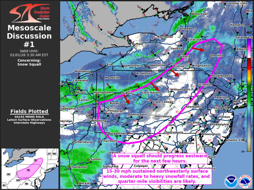
   Mesoscale Discussion 0001
   NWS Storm Prediction Center Norman OK
   1026 PM CST Wed Dec 31 2025

   Areas affected...portions of central and southern New York into
   central Pennsylvania...western Maryland...extreme northeastern West
   Virginia

   Concerning...Snow Squall

   Valid 010426Z - 010830Z

   SUMMARY...A snow squall should continue across portions of the
   northern Appalachians through at least early tonight. Brief periods
   of moderate to heavy snow, 30+ mph gusts, and rapidly reduced
   visibilities are all possible.

   DISCUSSION...Convergence along a surface cold front has increased
   over the past few hours as a 100+ kt 500 mb jet overspreads this
   boundary. As a result, a snow squall has developed. Reduced
   visibilities below a quarter mile have been observed, along with
   brief instances of moderate to heavy snowfall rates and gusts over
   30 mph. The snow squall is expected to persist across portions of
   the northern Appalachians over the next few hours as the parent
   mid-level trough continues to amplify over the region, further
   increasing deep-layer ascent and the strength of the leading line in
   turn. Within the strongest portion of the snow squall, a rapid onset
   of 0.5-1.0 inch/hour snowfall rates could occur, with a rapid
   veering of the surface winds to the northwest at 15-25 mph, with
   higher gusts likely. Visibilities may drop below a quarter mile
   where the stronger winds and higher snowfall rates coincide.

   ..Squitieri.. 01/01/2026

   ...Please see www.spc.noaa.gov for graphic product...

   ATTN...WFO...ALY...PHI...BGM...CTP...LWX...PBZ...

   LAT...LON   39437967 39748016 40148042 40478038 40808035 40897991
               41457812 42387641 42967567 43137482 42877442 42447453
               41837495 41157567 40527644 40117693 39747754 39427832
               39357896 39437967
|
|
|
Top/All Mesoscale Discussions/Forecast Products/Home |
|
Source link