| Mesoscale Discussion 2284 | |
| < Previous MD Next MD > | |
|
|
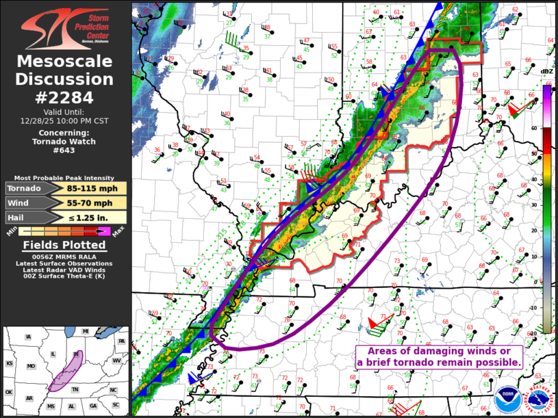
Mesoscale Discussion 2284 NWS Storm Prediction Center Norman OK 0658 PM CST Sun Dec 28 2025 Areas affected...central Indiana...western Kentucky and Tennessee...extreme southern Illinois Concerning...Tornado Watch 643... Valid 290058Z - 290400Z The severe weather threat for Tornado Watch 643 continues. SUMMARY...Areas of damaging gusts or perhaps a brief tornado remain possible from central Indiana southwestward into the lower Ohio Valley. Sporadic damaging gusts cannot be ruled out as far south as western Tennessee. DISCUSSION...A line of thunderstorms continues to move rapidly east coincident with the cold front, with indications of QLCS storm mode at times. Convective trends may be dwindling across the far northern areas, as the line encounters a relatively cooler boundary layer. Farther south toward the OH River and toward western KY and TN, temperatures remain in the 70s F with lower 60s F dewpoints. This is generally resulting in MLCAPE values of a few hundred J/kg. However, little instability is needed to persist the damaging wind threat as the line is strongly forced and with 50 kt around 1 km AGL. Low-level SRH is also strong with 0-1 km values to 400 m2/s2. Given the loss of heating and rapidly moving cold front, the severe storms risk is expected to last a few hours until the line pushes through the narrow instability axis. In the near term, the greatest risk areas continues to be within the tornado watch extending from central IN into western KY, and the watch may be locally extended in time or space as conditions warrant. ..Jewell.. 12/29/2025 ...Please see www.spc.noaa.gov for graphic product... ATTN...WFO...ILN...LMK...OHX...IND...PAH...MEG... LAT...LON 36048994 37408883 38448738 39798622 40208580 40198535 39688521 38788545 37978603 36698737 35938842 35718910 35708968 35888995 36048994 MOST PROBABLE PEAK TORNADO INTENSITY...85-115 MPH MOST PROBABLE PEAK WIND GUST...55-70 MPH MOST PROBABLE PEAK HAIL SIZE...UP TO 1.25 IN |
|
|
Top/All Mesoscale Discussions/Forecast Products/Home |
|
Source link