| Mesoscale Discussion 2282 | |
| < Previous MD | |
|
|
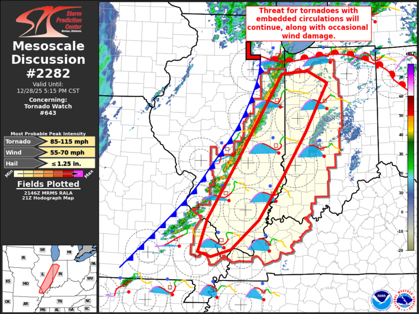
Mesoscale Discussion 2282 NWS Storm Prediction Center Norman OK 0349 PM CST Sun Dec 28 2025 Areas affected...Extreme southeast Missouri...southern and eastern Illinois...and western Indiana Concerning...Tornado Watch 643... Valid 282149Z - 282315Z The severe weather threat for Tornado Watch 643 continues. SUMMARY...The threat for occasional damaging gusts and tornadoes with embedded circulations will continue as storms consolidate and spread eastward across Illinois toward Indiana. DISCUSSION...Over the past hour, a line of thunderstorms has consolidated along the cold front moving quickly eastward across Illinois. A corridor of weak buoyancy precedes the front, where surface temperatures peaked in the mid 60s to lower 70s, in the presence of lower 60s dewpoints. Recent observations from KILX revealed a tornadic debris signature southeast-through-east of Decatur, IL, with a circulation embedded in the line. Additional tornadoes will be possible given the long, low-level hodographs and substantial (200-300 m2/s2) SRH in the storm inflow, within a sufficiently moist and weakly unstable pre-storm environment. Additional storm development is expected farther south along the front toward extreme southeast MO and southern IL over the next 1-2 hours. Though the loss of surface heating will result in a gradual reduction in buoyancy with eastward extent, strong wind profiles will help maintain the potential for a few tornadoes and damaging gusts into late evening. ..Thompson.. 12/28/2025 ...Please see www.spc.noaa.gov for graphic product... ATTN...WFO...IWX...IND...PAH...LOT...ILX...LSX... LAT...LON 40498806 41168761 41238685 40968628 39858691 38848759 37878829 37198907 37038965 37149002 37898975 39228889 40498806 MOST PROBABLE PEAK TORNADO INTENSITY...85-115 MPH MOST PROBABLE PEAK WIND GUST...55-70 MPH MOST PROBABLE PEAK HAIL SIZE...UP TO 1.25 IN |
|
|
Top/All Mesoscale Discussions/Forecast Products/Home |
|
Source link