| Mesoscale Discussion 2281 | |
| < Previous MD | |
|
|
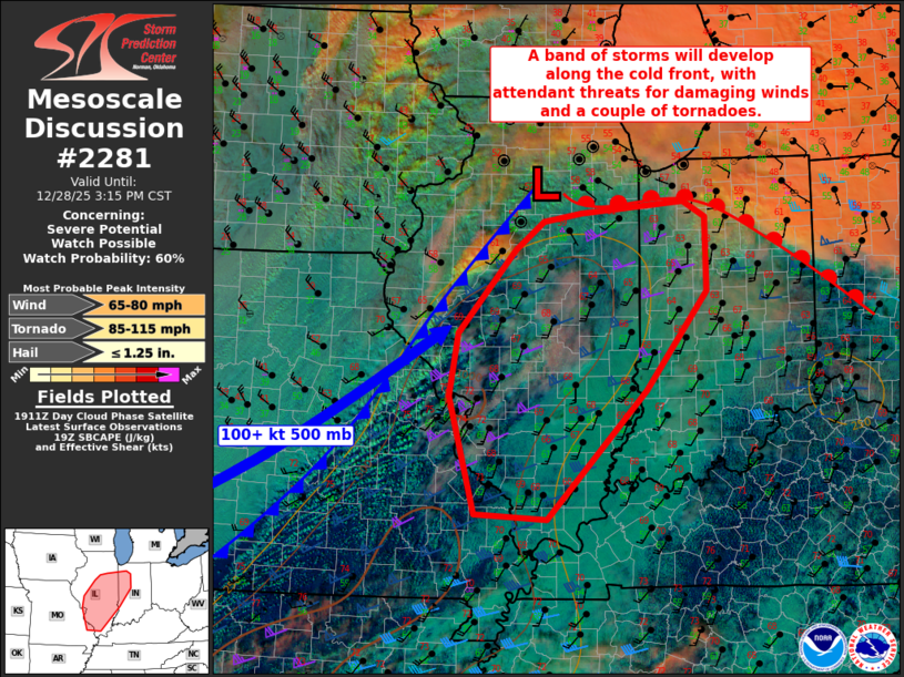
   Mesoscale Discussion 2281
   NWS Storm Prediction Center Norman OK
   0118 PM CST Sun Dec 28 2025

   Areas affected...Far eastern Missouri...central and southern
   Illinois...and western Indiana

   Concerning...Severe potential...Watch possible

   Valid 281918Z - 282115Z

   Probability of Watch Issuance...60 percent

   SUMMARY...A band of storms is expected to form along the cold front
   by mid afternoon in Illinois and spread eastward through late
   evening into Indiana.  Occasional wind damage and a couple of
   tornadoes will be the main threats, and a watch is possible by
   20-21z.

   DISCUSSION...A surface cyclone is in the early stages of deepening
   along a baroclinic zone across northern IL, downstream from an
   amplifying midlevel trough and associated 100+ kt midlevel jet.
   Within the warm sector of the cyclone, visible satellite imagery
   shows some cloud breaks from MO into central IL, where surface
   temperatures have warmed to 68+ F with dewpoints in the low 60s.
   Surface-based CAPE has increased to 500-1000 J/kg as convective
   inhibition weakens immediately ahead of the front.  Shallow
   convection is ongoing in the zone of ascent along the front, and the
   threat for thunderstorms will increase through late afternoon as the
   front interacts with the moist/weakly unstable boundary layer into
   IL.

   Strong deep-layer shear/long hodographs favor supercells.  Still,
   relatively weak buoyancy, linear forcing for ascent and fairly fast
   frontal movement favor a more linear storm mode tied closely to the
   frontal circulation.  Thus, a mixed convective mode is probable,
   with damaging gusts the main threat given roughly 50 kt flow in the
   lowest 1-2 km above ground level.  A couple of tornadoes may also
   occur with any sustained supercells and/or embedded circulations
   within line segments.  A watch may need to be considered by 20-21z.

   ..Thompson/Gleason.. 12/28/2025

   ...Please see www.spc.noaa.gov for graphic product...

   ATTN...WFO...IWX...IND...PAH...LOT...ILX...LSX...

   LAT...LON   38998743 37448896 37519006 38929046 39679034 40678945
               41028902 41118844 41258684 41068649 40188648 38998743

   MOST PROBABLE PEAK TORNADO INTENSITY...85-115 MPH
   MOST PROBABLE PEAK WIND GUST...65-80 MPH
   MOST PROBABLE PEAK HAIL SIZE...UP TO 1.25 IN
|
|
|
Top/All Mesoscale Discussions/Forecast Products/Home |
|
Source link