| Mesoscale Discussion 2239 | |
| < Previous MD | |

|
|
Mesoscale Discussion 2239
NWS Storm Prediction Center Norman OK
1042 AM CST Sat Nov 29 2025
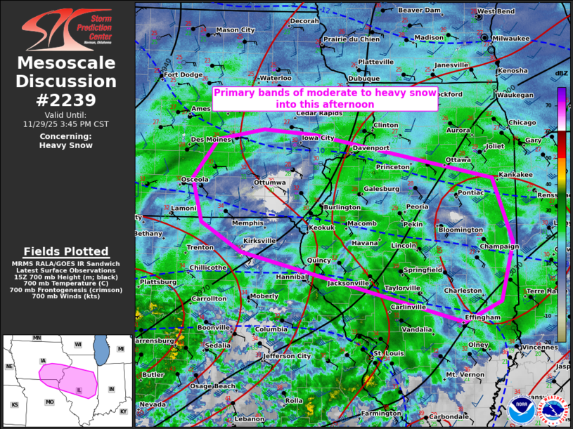
Areas affected...parts of IL...southeast IA...and far northeast MO
Concerning...Heavy snow
Valid 291642Z - 292145Z
SUMMARY...Primary bands of moderate to sporadic heavy snow should
pivot from south-central across southeast Iowa, and persist across
much of central into northern Illinois through this afternoon. Rates
around 1 inch per hour should occasionally occur.
DISCUSSION...Long-duration snowfall event will persist through the
afternoon, shifting eastward to the northeast of a surface cyclone
near the western Kansas City Metro Area. Ongoing heavy snow band
across south-central IA should largely pivot across southeast IA and
perhaps expand as the strongest mid-level DCVA shifts across eastern
IA this afternoon. Farther east, the persistent low-level warm
conveyor will maintain a broad swath of moderate snow across central
to northern IL. While the bulk of the ascent should remain beneath
the dendritic growth zone centered around 550 mb, strengthening
mid-level DCVA should foster sporadic bursts of heavier snow.
Snowfall rates within these regimes should occasionally reach 1
in/hr.
..Grams.. 11/29/2025
...Please see www.spc.noaa.gov for graphic product...
ATTN...WFO...LOT...ILX...LSX...DVN...DMX...EAX...
LAT...LON 40109261 40519334 41149351 41689305 41839219 41769124
41148796 40248759 39418782 39118851 40109261
|
|
|
Top/All Mesoscale Discussions/Forecast Products/Home |
|
Source link