| Mesoscale Discussion 2235 | |
| < Previous MD | |

|
|
Mesoscale Discussion 2235
NWS Storm Prediction Center Norman OK
0530 AM CST Thu Nov 27 2025
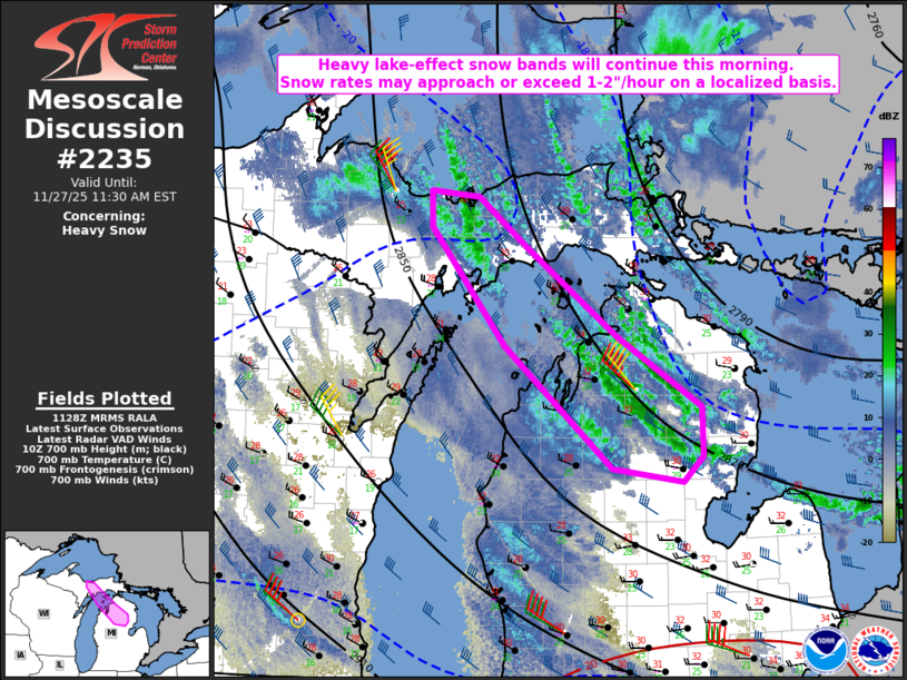
Areas affected...Parts of central Upper MI into northern Lower MI
Concerning...Heavy snow
Valid 271130Z - 271630Z
SUMMARY...Heavy lake-effect snow bands will continue through the
morning. Snow rates may approach or exceed 1-2 inches per hour on a
localized basis.
DISCUSSION...Cold cyclonic flow associated with a deep low over
western Quebec has generated several lake-effect snow bands over the
Great Lakes region. In particular, multiple snow bands are affecting
northern Lower MI this morning, with some apparent upstream
connection to bands across central Upper MI that are emanating from
Lake Superior. The KAPX and KMQT VWPs depict little change to the
low-level wind field over the last several hours, and guidance
generally suggests this northwesterly flow regime will remain
relatively unchanged through the remainder of the morning. This
should allow ongoing bands to persist, while some cooling aloft
(with 700 mb temperatures dropping to near/below -20 C) may
gradually increase snow-to-liquid ratios with time. Snow rates of
1-2 inches/hour (locally greater) will be possible within these
bands, especially if a dominant single band can develop. Wind gusts
of 30-45 mph combined with the locally heavy snow rates will result
in significant visibility reductions in and near the strongest
bands.
..Dean.. 11/27/2025
...Please see www.spc.noaa.gov for graphic product...
ATTN...WFO...APX...MQT...
LAT...LON 46488655 46088599 45348492 44758394 44358393 44148417
44248498 45268623 46238709 46538710 46488655
|
|
|
Top/All Mesoscale Discussions/Forecast Products/Home |
|
Source link