| Mesoscale Discussion 2229 | |
| < Previous MD | |

|
|
Mesoscale Discussion 2229
NWS Storm Prediction Center Norman OK
0554 AM CST Tue Nov 25 2025
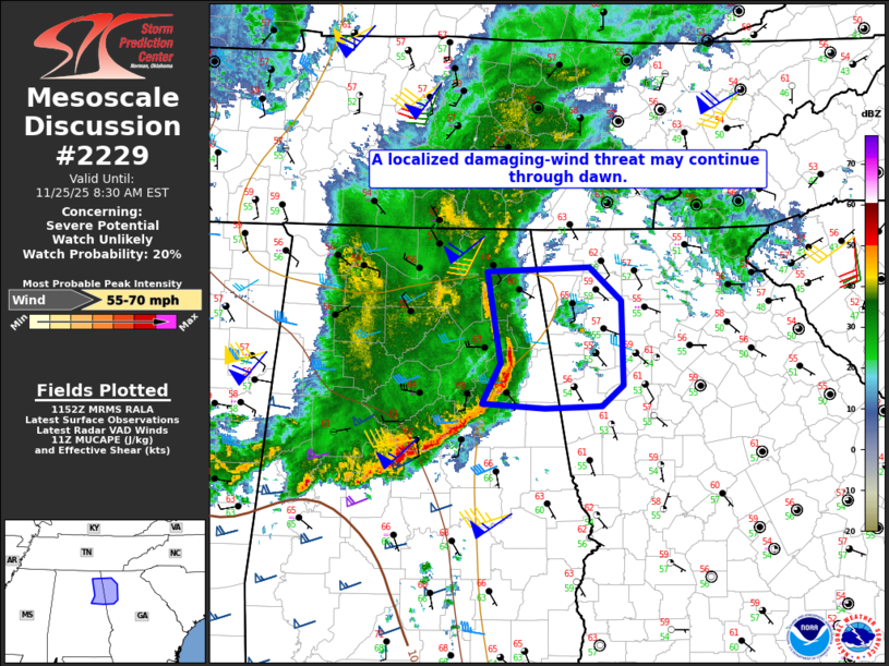
Areas affected...Northeast AL into far northwest GA
Concerning...Severe potential...Watch unlikely
Valid 251154Z - 251330Z
Probability of Watch Issuance...20 percent
SUMMARY...A localized damaging-wind threat may continue through
dawn.
DISCUSSION...A small but long-lived bowing segment with a history of
producing wind damage is moving quickly eastward across northeast AL
as of 1145 UTC. Increasingly scant buoyancy and cool surface
temperatures downstream of this bow should eventually result in a
weakening trend later this morning. However, given the presence of a
strong rear-inflow jet (as observed in the KGWX and KBMX VWPs) and
well-defined surface pressure perturbation, some damaging-wind
potential may spread into parts of northwest GA before a more
definitive weakening trend occurs.
..Dean/Hart.. 11/25/2025
...Please see www.spc.noaa.gov for graphic product...
ATTN...WFO...FFC...BMX...HUN...
LAT...LON 33488609 33828590 34618605 34668498 34378465 33638464
33468486 33438545 33488609
MOST PROBABLE PEAK WIND GUST...55-70 MPH
|
|
|
Top/All Mesoscale Discussions/Forecast Products/Home |
|
Source link