| Mesoscale Discussion 2223 | |
| < Previous MD | |

|
|
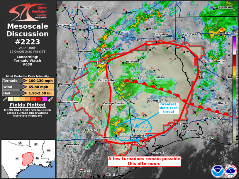
Mesoscale Discussion 2223 NWS Storm Prediction Center Norman OK 0107 PM CST Mon Nov 24 2025 Areas affected...portions of east-central into southeast Texas Concerning...Tornado Watch 638... Valid 241907Z - 242030Z The severe weather threat for Tornado Watch 638 continues. SUMMARY...A few tornadoes remain possible with ongoing storms across east-central into southeastern Texas. DISCUSSION...Supercell structures have percolated in intensity along a confluence band within the free warm sector, ahead of a surface cold front. Ahead of the storms, surface temperatures have warmed well into the 70s F (near 80 F in the Houston area), with dewpoints in the upper 60s to low 70s F noted. However, regional VADs have shown relatively short hodographs with modest curvature, which may be limiting tornado potential up to this point. Nonetheless, an uptick in tornado development may occur over the next couple of hours. A particular region of concern would be over the northern Houston metropolitan area, where regional/terminal radar data shows the intensification of a supercell amid a moderately unstable airmass, with a 30+ kt rotational velocity noted with the 1903Z 0.5 degree KHGX velocity scan. ..Squitieri.. 11/24/2025 ...Please see www.spc.noaa.gov for graphic product... ATTN...WFO...LCH...SHV...HGX...FWD... LAT...LON 29659616 29759624 29929622 30079617 30459610 31049608 31299616 31449620 31589622 31719622 31779620 31849612 32029562 32309498 32279492 32339432 32209370 31949336 31459333 30909363 30229396 29929437 29719496 29629548 29609576 29659616 MOST PROBABLE PEAK TORNADO INTENSITY...100-130 MPH MOST PROBABLE PEAK WIND GUST...65-80 MPH MOST PROBABLE PEAK HAIL SIZE...1.50-2.50 IN |
|
|
Top/All Mesoscale Discussions/Forecast Products/Home |
|
Source link


