| Mesoscale Discussion 2217 | |
| < Previous MD | |

|
|
   Mesoscale Discussion 2217
   NWS Storm Prediction Center Norman OK
   1134 PM CST Fri Nov 21 2025

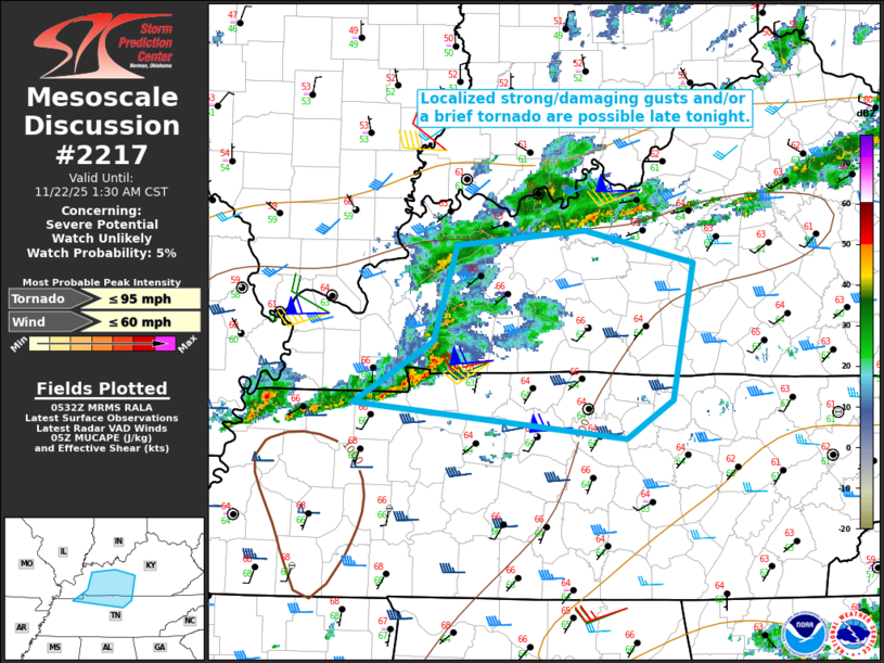
   Areas affected...Parts of southwest KY into far northern TN

   Concerning...Severe potential...Watch unlikely

   Valid 220534Z - 220730Z

   Probability of Watch Issuance...5 percent

   SUMMARY...Localized strong/damaging gusts and/or a brief tornado are
   possible late tonight.

   DISCUSSION...A small storm cluster is moving across far western KY
   to near the TN state line late this evening. While instability is
   modest at best (with MLCAPE of around 500 J/kg), ascent attendant to
   a midlevel shortwave trough approaching the Ohio Valley may help to
   sustain this cluster as it moves eastward late tonight. Midlevel
   flow and deep-layer shear (as sampled by the KPAH and KHPX VWPs) are
   rather strong, which could allow for convection to remain somewhat
   organized as it moves eastward. Mostly unidirectional wind profiles
   may continue to favor a quasi-linear mode, though a transient
   embedded supercell or two (as recently noted near the KY/TN border)
   cannot be ruled out.

   Weak lapse rates and modest buoyancy will tend to limit the
   magnitude of the severe threat. However, locally gusty/damaging
   winds will be possible into the early overnight, and a brief/weak
   tornado cannot be ruled out with any persistent supercell
   structures, with 0-1 km SRH of 100-150 m2/s2 in place per the KHPX
   VWP.

   ..Dean/Smith.. 11/22/2025

   ...Please see www.spc.noaa.gov for graphic product...

   ATTN...WFO...LMK...OHX...PAH...MEG...

   LAT...LON   37578760 37678645 37448545 36438564 36158607 36428854
               36878781 37578760

   MOST PROBABLE PEAK TORNADO INTENSITY...UP TO 95 MPH
   MOST PROBABLE PEAK WIND GUST...UP TO 60 MPH
|
|
|
Top/All Mesoscale Discussions/Forecast Products/Home |
|
Source link


