| Mesoscale Discussion 2216 | |
| < Previous MD | |

|
|
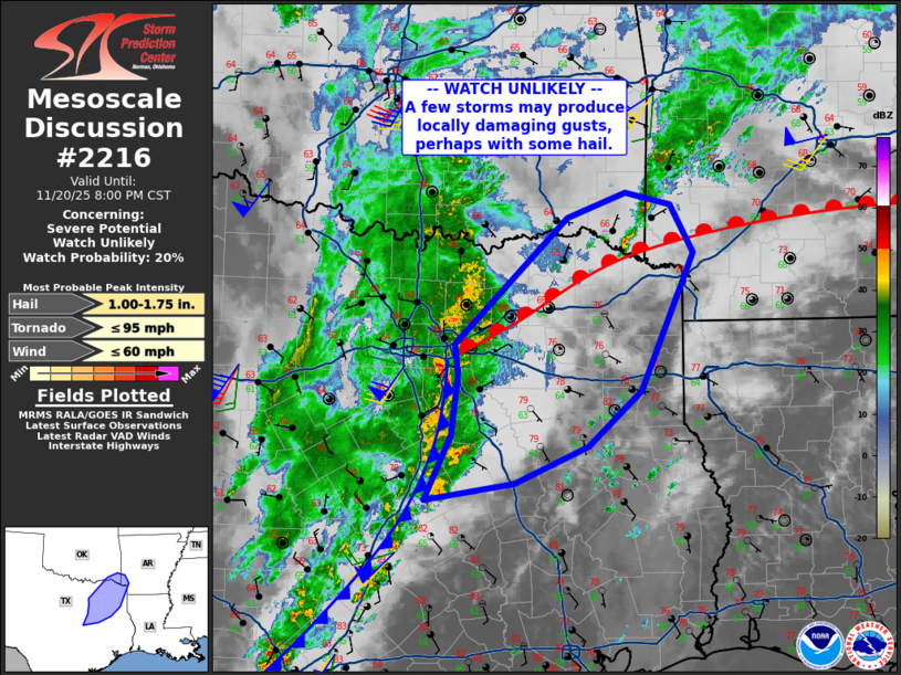
   Mesoscale Discussion 2216
   NWS Storm Prediction Center Norman OK
   0534 PM CST Thu Nov 20 2025

   Areas affected...over northeast Texas and into far southwest
   Arkansas

   Concerning...Severe potential...Watch unlikely

   Valid 202334Z - 210200Z

   Probability of Watch Issuance...20 percent

   SUMMARY...A severe storm or two may affect parts of northeast Texas
   and vicinity this evening. Locally damaging gusts along with hail
   over 1.00" diameter may occur.

   DISCUSSION...Surface analysis shows a moist air mass over eastern
   TX, east of a cold front and south of a warm front which is nearly
   stationary. Surface winds are generally weak across the moist sector
   with little surface pressure gradient. This weakness extends up to
   850 mb as well, where speeds are on the order of 20-25 kt.

   While cool midlevel temperatures remain over the area, the primary
   trough continues to eject northeastward from the TX Panhandle into
   western OK, with strong midlevel warming to the south. East of this
   wave, height tendencies are forecast to remain rather neutral.
   Still, moderate mid and high level southwesterlies are resulting in
   effective shear around 50 kt. These elongated hodographs
   conditionally favor a few longer lived cells off the cold front.

   Areas of stronger cells currently extend from Ellis County into
   Limestone/Falls Counties. The Ellis County complex is near the warm
   front, and may persist as it rides along that boundary, with
   enhanced ascent and gusty wind potential.

   ..Jewell/Smith.. 11/20/2025

   ...Please see www.spc.noaa.gov for graphic product...

   ATTN...WFO...LZK...SHV...TSA...FWD...

   LAT...LON   31239705 31899674 32489667 32799671 34059540 34309470
               34179418 33699391 32329453 31789515 31419600 31239705

   MOST PROBABLE PEAK TORNADO INTENSITY...UP TO 95 MPH
   MOST PROBABLE PEAK WIND GUST...UP TO 60 MPH
   MOST PROBABLE PEAK HAIL SIZE...1.00-1.75 IN
|
|
|
Top/All Mesoscale Discussions/Forecast Products/Home |
|
Source link