| Mesoscale Discussion 2206 | |
| < Previous MD | |
|
|
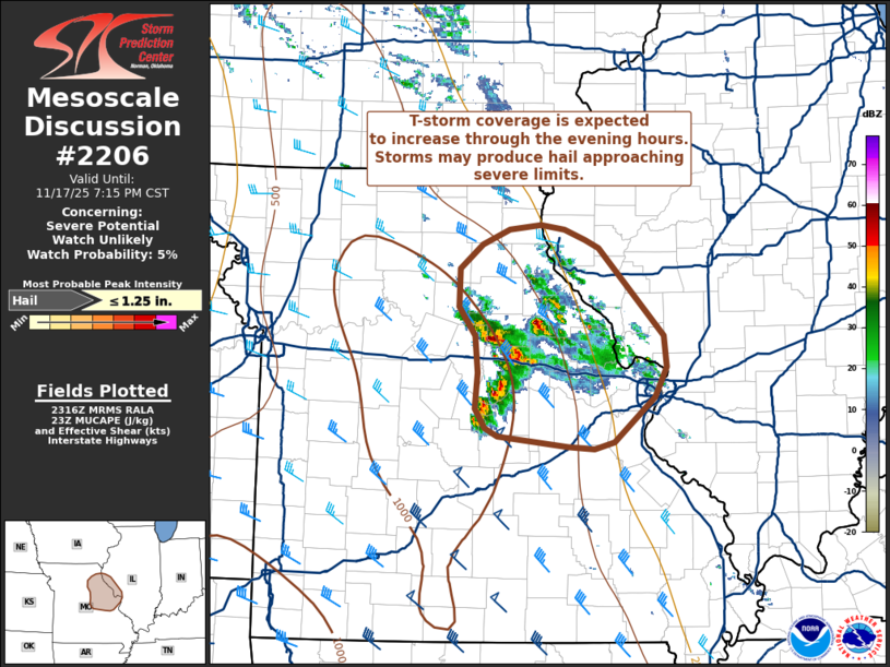
   Mesoscale Discussion 2206
   NWS Storm Prediction Center Norman OK
   0518 PM CST Mon Nov 17 2025

   Areas affected...Eastern Missouri into far western Illinois

   Concerning...Severe potential...Watch unlikely

   Valid 172318Z - 180115Z

   Probability of Watch Issuance...5 percent

   SUMMARY...A cluster of thunderstorms will likely increase in
   coverage over the next few hours across eastern Missouri and into
   far western Illinois. While most storms should remain sub-severe, a
   few stronger cores my periodically be capable of producing hail near
   severe limits.

   DISCUSSION...Recent GOES IR imagery and MRMS data show a steady
   uptick in new updrafts within a growing cluster of thunderstorms
   just east of the Columbia, MO area. This cluster has a history of
   mainly producing sub-severe hail (0.25 to 0.75 inches per mPING
   reports), but occasional hail stones up to 1 inch have been
   reported. The developing thunderstorms are maturing in a similar
   thermodynamic and kinematic environment (characterized by modest
   MUCAPE, but strong shear through the CAPE-bearing layer), and will
   likely see periodic upticks in intensity that may support instances
   of hail near 1 inch. As thunderstorm coverage increases, storm
   interactions may act to modulate the severe threat further; however,
   continued eastward advection of a plume of ~7 C/km lapse rates and
   low-level moistening/isentropic ascent should continue to promote
   thunderstorm development for the next few hours into far western IL.
   Given the overall modest thermodynamic environment and expectation
   for mainly sub-severe hail, watch issuance is not expected.

   ..Moore/Hart.. 11/17/2025

   ...Please see www.spc.noaa.gov for graphic product...

   ATTN...WFO...ILX...LSX...SGF...EAX...

   LAT...LON   38229070 38179092 38199121 38289198 38349212 38529223
               38829221 39159223 39409242 39729240 39949216 40079185
               40109150 40079124 39979101 39919086 39159014 38879011
               38619024 38229070

   MOST PROBABLE PEAK HAIL SIZE...UP TO 1.25 IN
|
|
|
Top/All Mesoscale Discussions/Forecast Products/Home |
|
Source link