|
|
| Mesoscale Discussion 2204 | |
|
|
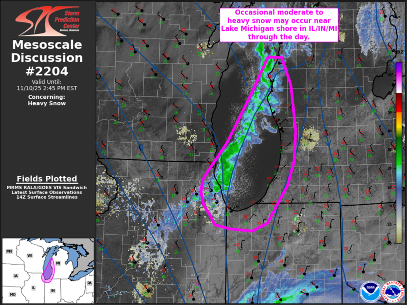
   Mesoscale Discussion 2204
   NWS Storm Prediction Center Norman OK
   0847 AM CST Mon Nov 10 2025

   Areas affected...northeast IL...northwest IN...and western Lower MI

   Concerning...Heavy snow

   Valid 101447Z - 101945Z

   SUMMARY...Brief periods of moderate to heavy lake effect snow may
   impact southeastern Lake Michigan vicinity through the day as the
   snow back shift east/southeast.

   DISCUSSION...A band of lake effect snow is oriented from western
   Lower MI to northeast IL this morning. This band is expected to
   pivot east/southeast over time as low-level winds shift to
   northwesterly with time and eastward extent. Areas along the
   southeastern shore of Lake Michigan will see periods of moderate to
   heavy snow as the band progresses east/southeast through the day. A
   lack of stronger frontogenesis should temper overall snowfall rates,
   but brief periods of near 1 inch per hour rates will be possible.

   ..Leitman.. 11/10/2025

   ...Please see www.spc.noaa.gov for graphic product...

   ATTN...WFO...APX...IWX...GRR...LOT...MKX...

   LAT...LON   42168810 42278801 42858751 43758691 44378651 44368617
               43878596 43048584 42508590 42088606 41678635 41408654
               41258690 41298744 41378780 41528789 41728807 41958813
               42168810
|
|
|
Top/All Mesoscale Discussions/Forecast Products/Home |
|
Source link