|
|
| Mesoscale Discussion 2203 | |
|
|
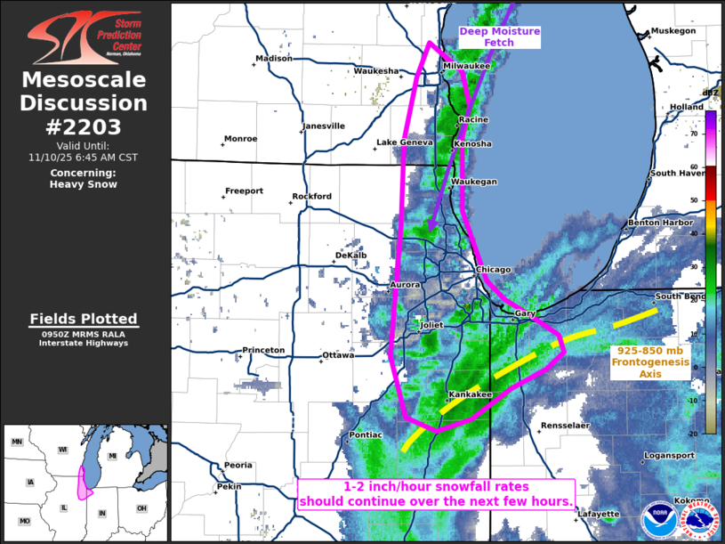
   Mesoscale Discussion 2203
   NWS Storm Prediction Center Norman OK
   0352 AM CST Mon Nov 10 2025

   Areas affected...portions of extreme southeast Wisconsin into far
   northeastern Illinois and extreme northwestern Indiana

   Concerning...Heavy snow

   Valid 100952Z - 101245Z

   SUMMARY...Heavy snow will continue with ongoing lake-effect snow
   bands for at least a few more hours, with 1-2 inch/hour snowfall
   rates expected.

   DISCUSSION...Heavy snow continues to be reported with a primary snow
   band along the Lake Michigan/WI/IL shoreline. This snow band is
   oriented roughly parallel to the 925-700 mb mean wind, which
   features a broad, deep fetch of moisture off of Lake Michigan. This
   scenario is optimal for the snow band to remain roughly stationary,
   with continued heavy snow occurring with likely low-topped
   convection (given 250 J/kg MUCAPE just offshore per 09Z
   mesoanalysis). Given saturation within the dendritic growth zone,
   along with the likely convective nature of the snowband, 1-2
   inch/hour snowfall rates are likely through at least 12Z. Similar
   snowfall rates should also continue south of the Chicago
   metropolitan area, where low-level frontogenesis is maximized.

   ..Squitieri.. 11/10/2025

   ...Please see www.spc.noaa.gov for graphic product...

   ATTN...WFO...LOT...MKX...

   LAT...LON   41828755 41718741 41628721 41508698 41408695 41298708
               41188735 41008767 40938793 41018817 41378830 42148822
               42638819 43008809 43218799 43038774 42838767 42668774
               42238773 41968761 41828755
|
|
|
Top/All Mesoscale Discussions/Forecast Products/Home |
|
Source link