|
|
| Mesoscale Discussion 2201 | |
|
|
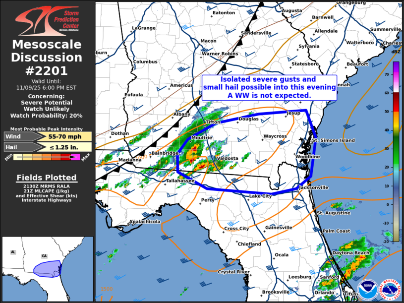
   Mesoscale Discussion 2201
   NWS Storm Prediction Center Norman OK
   0332 PM CST Sun Nov 09 2025

   Areas affected...portions of south Georgia and northern Florida

   Concerning...Severe potential...Watch unlikely

   Valid 092132Z - 092300Z

   Probability of Watch Issuance...20 percent

   SUMMARY...Isolated severe gusts and some hail risk will remain
   possible late this afternoon and into the evening hours ahead of a
   loosely organized band of storms near the FL/GA border.

   DISCUSSION...As of 2125 UTC, regional radar analysis showed a
   loosely organized cluster of thunderstorms ongoing along a diffuse
   frontal zone from southwestern GA into the FL Panhandle. Over the
   last hour, these storms have gradually intensified with reports of
   wind damage and measured gusts. Driven primarily by surface heating
   of a partially modified air mass, around 1000 J/kg of MLCAPE is in
   place and is sufficient for maintenance of occasional stronger
   updrafts as storms continue eastward. Behind the primary frontal
   wind shift with veered surface flow, overlapping stronger flow aloft
   is largely front parallel. This is supporting elongated (0-6km shear
   50+ kt) but relatively straight hodographs as indicated by area
   VADs. This should continue to favor a mixed convective mode with a
   few supercell and linear structures.

   Radar trends and CAM guidance suggest intermittent organization
   remains possible over the next few hours as storms track eastward
   along the FL/GA border. Some guidance shows additional upscale
   growth is likely into early evening. The highest risk for severe
   gusts and some hail is expected with any of the more established
   supercells or bowing segments able to evolve. But with only modest
   mid-level lapse rates and continued undercutting by the advancing
   front, a broader and sustained severe risk necessitating WW issuance
   appears unlikely.

   ..Lyons/Smith.. 11/09/2025

   ...Please see www.spc.noaa.gov for graphic product...

   ATTN...WFO...CHS...JAX...TAE...

   LAT...LON   30378345 30648402 30968403 31218384 31498329 31648243
               31718147 31248129 30578140 30378169 30278218 30378345

   MOST PROBABLE PEAK WIND GUST...55-70 MPH
   MOST PROBABLE PEAK HAIL SIZE...UP TO 1.25 IN
|
|
|
Top/All Mesoscale Discussions/Forecast Products/Home |
|
Source link