|
|
| Mesoscale Discussion 2174 | |
|
|
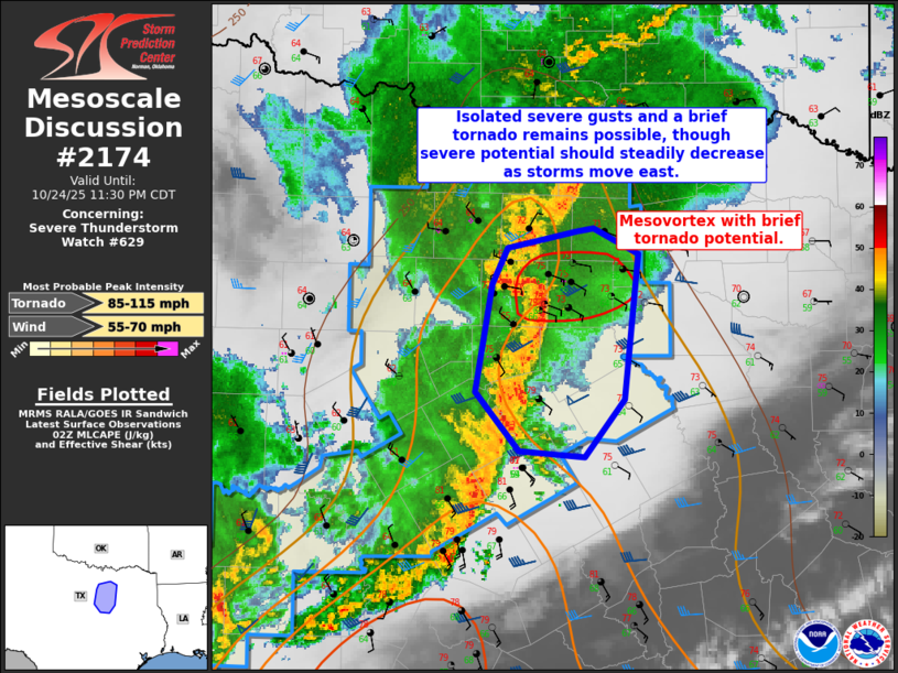
Mesoscale Discussion 2174 NWS Storm Prediction Center Norman OK 0933 PM CDT Fri Oct 24 2025 Areas affected...Portions of North/Central Texas Concerning...Severe Thunderstorm Watch 629... Valid 250233Z - 250430Z The severe weather threat for Severe Thunderstorm Watch 629 continues. SUMMARY...A mesovortex circulation will be the focus for additional severe gusts and perhaps a brief tornado. Severe potential is greatest where temperatures remain in the mid 70s F. DISCUSSION...The line segment that has passed through parts of the DFW metro produced at least one severe gusts in Fort Worth in association with a mesovortex circulation. Where temperatures are in the mid 70s F (such as the current DAL observation) severe potential--including the risk for additional severe gusts and a brief tornado--will be greatest. Farther east, both temperatures and dewpoints are not nearly as supportive and a steady decline in intensity is expected east of the DFW metro. ..Wendt.. 10/25/2025 ...Please see www.spc.noaa.gov for graphic product... ATTN...WFO...FWD... LAT...LON 32129758 32839745 33069734 33179679 33199667 33039631 32079643 31699674 31729724 32129758 MOST PROBABLE PEAK TORNADO INTENSITY...85-115 MPH MOST PROBABLE PEAK WIND GUST...55-70 MPH |
|
|
Top/All Mesoscale Discussions/Forecast Products/Home |
|
Source link