|
|
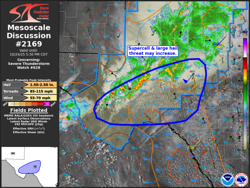
| Mesoscale Discussion 2169 | |
|
|
Mesoscale Discussion 2169 NWS Storm Prediction Center Norman OK 0255 PM CDT Fri Oct 24 2025 Areas affected...southwest Texas Concerning...Severe Thunderstorm Watch 628... Valid 241955Z - 242230Z The severe weather threat for Severe Thunderstorm Watch 628 continues. SUMMARY...A possible supercell with large hail potential appears evident over parts of southwest Texas over the next several hours. DISCUSSION...Substantial thunderstorm activity currently extends from Jeff Davis county east/northeastward into the San Angelo area, with widespread rain and storms northward into much of northwest Texas. The strongest activity remains along the southern periphery of this activity where the storms have access to the warmer air mass. Surface observations from the Big Bend areas into west-central Texas show temperatures have risen into the 80s F while dewpoints remain in the low 60s F. Meanwhile, temperatures aloft continue to cool. Mixed-mode severe storms are currently ongoing in this corridor, which is also beneath the stronger upper-level jet. It is possible toward the peak heating hours that a cell or two could produce hail over 2.00" diameter, and/or move in more of an eastward direction as the warmer air mass/SBCAPE aids rightward propagation and supercell mode. ..Jewell.. 10/24/2025 ...Please see www.spc.noaa.gov for graphic product... ATTN...WFO...EWX...SJT...MAF... LAT...LON 30710373 31310250 31640149 31840026 31350001 30610023 29890079 29760352 30210414 30710373 MOST PROBABLE PEAK TORNADO INTENSITY...85-115 MPH MOST PROBABLE PEAK WIND GUST...55-70 MPH MOST PROBABLE PEAK HAIL SIZE...1.50-2.50 IN |
|
|
Top/All Mesoscale Discussions/Forecast Products/Home |
|
Source link