|
|
| Mesoscale Discussion 2167 | |

|
|
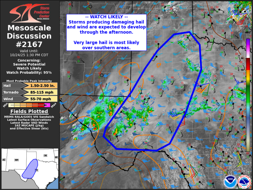
   Mesoscale Discussion 2167
   NWS Storm Prediction Center Norman OK
   1105 AM CDT Fri Oct 24 2025

   Areas affected...much of western Texas

   Concerning...Severe potential...Watch likely

   Valid 241605Z - 241830Z

   Probability of Watch Issuance...95 percent

   SUMMARY...Storms capable of large, damaging hail and eventually
   damaging winds are likely to develop this afternoon from southwest
   into much of western Texas.

   DISCUSSION...Cooling aloft with a shortwave trough is already aiding
   the development of thunderstorms containing hail over Far West TX
   this morning. Substantial high clouds are currently limiting surface
   heating over much of the region, but breaks in the clouds as well as
   eventual boundary layer mixing with gusty south winds will
   accelerate warming over the next several hours.

   Surface analysis indicates the ongoing activity is just west of the
   better low-level moisture where dewpoints are in the lower 60s F.
   Despite the clouds and only modest surface warming, forecast
   soundings indicate strong instability will develop as mid and upper
   level lapse rates steepen. MLCAPE over 1500 J/kg is likely, with
   greater values where heating is stronger.

   Effective deep-layer shear of 40-50 kt as well as modest low-level
   veering with height will favor supercells for a few hours, with
   locally significant hail possible. A tornado or two is possible with
   the stronger supercells that may develop, with sufficient effective
   SRH increasing toward 200 m2/s2 by 00Z

   ..Jewell/Leitman.. 10/24/2025

   ...Please see www.spc.noaa.gov for graphic product...

   ATTN...WFO...OUN...EWX...SJT...LUB...MAF...

   LAT...LON   29850367 30360429 30730418 32220299 33160236 33900176
               34550093 34650018 34129968 33109963 31330043 30080119
               29810180 29850367

   MOST PROBABLE PEAK TORNADO INTENSITY...85-115 MPH
   MOST PROBABLE PEAK WIND GUST...55-70 MPH
   MOST PROBABLE PEAK HAIL SIZE...1.50-2.50 IN
|
|
|
Top/All Mesoscale Discussions/Forecast Products/Home |
|
Source link