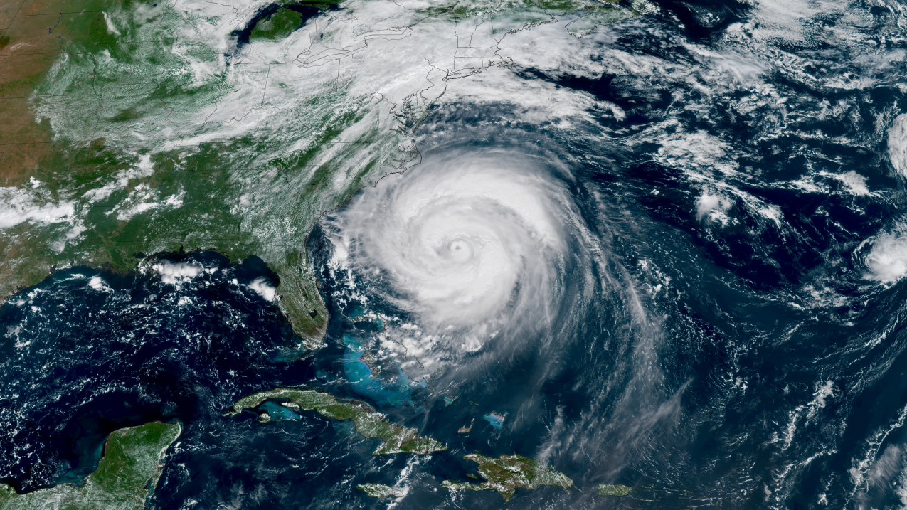
Although the eye of Hurricane Erin was never closer than about 200 miles from the U.S. East Coast and its center never made landfall, Erin’s effects were still seen along the shoreline and felt by coastal communities. The massive circulation of this powerful storm was a clear demonstration of how distant hurricanes still pose a danger to life and property.
As Erin passed by off the U.S. eastern seaboard last month, its rip currents and rough surf kept beachgoers out of the water. Waves as high as 50 feet near the storm’s center gave good reason for boats and ships in the Atlantic Ocean to steer clear.
When storms like Erin threaten, NOAA’s National Weather Service provides forecasts, warnings, and life-saving information to thousands of partners in local, regional and national jurisdictions to help keep Americans safe and to minimize weather-related disruptions to the economy.
Keeping people safe when rip currents are present
This year, NOAA’s National Hurricane Center launched a new rip current risk graphic designed to better inform citizens and decision-makers about localized rip current hazards. This enhanced messaging put the focus on the biggest threat posed by Erin to Americans – the high risk of deadly rip currents – and helped emergency managers and other partners disseminate life-saving information to coastal communities.
Preparing partners to protect the public
The local NWS office in Morehead City, NC., which serves the Outer Banks of North Carolina, helped local emergency managers prepare for the impacts of Erin by posting daily livestreamed briefings for the general public on YouTube and emailing more comprehensive briefings to emergency managers and other partners twice a day. These briefings began five days in advance of Erin’s anticipated impacts on North Carolina’s coastline, giving partners ample time to prepare and issue evacuation orders if necessary.
Inland NWS offices also had a pivotal role, posting critical safety information for Americans traveling to coastal communities to enjoy the summer shore season. East Coast beaches from Florida to Massachusetts announced closures or swimming restrictions after receiving information from NWS and partners. These proactive notifications reached millions of Americans, providing lifesaving information and preventing an increased need for surf zone rescues, which can be both costly and dangerous for first responders.
Providing safe passage for ships
NOAA’s Ocean Prediction Center and the National Hurricane Center support all shipping interests to ensure cargo arrives safely and on schedule. Hurricane Erin’s massive seas and swells made this task a bigger challenge than usual.
In anticipation of this challenge, OPC and NHC provided briefings to partners such as the U.S. Coast Guard as early as August 12, over a week ahead of the heaviest impacts to ports along the U.S. East Coast. Headlines at the top of the OPC briefing slides signaled a clear “CALL TO ACTION: Mariners should be executing avoidance plans now!”
In total, OPC delivered nine briefings to the U.S. Coast Guard, starting with initial indications that a tropical storm may form, throughout Erin’s journey. Ships showed notable avoidance of Erin’s path, with the vast majority of marine traffic getting out of the path of tropical-storm-force winds well in advance of Erin. Ships kept a wide berth as Erin passed, quickly reestablishing their routes as soon as possible behind the storm.
The National Hurricane Center’s Tropical Analysis and Forecast Branch (TAFB) communicated daily with the U.S. Coast Guard Southeast District in the days leading up to and through Erin’s passage via their marine forecast zone, providing 13 live briefings during that period. As a result, the Southeast District restricted ports in the U.S. Virgin Islands and Puerto Rico during Erin’s passage – safely guiding hundreds of millions of dollars of trade goods to these local economies without loss or negative impacts.
Stay informed
The National Hurricane Center’s website, hurricanes.gov, is the leading source of information about tropical storm and hurricane activity throughout hurricane season. You can also find regular updates from NHC on X at @NHC_Atlantic offsite link, on Facebook, and on Instagram.
You can find the forecast for your location — or the one you may be traveling to — anytime by visiting weather.gov.
And for those with marine interests, the Ocean Prediction Center’s website is a mobile-friendly website for mariners to easily access on the go.
Source link