|
|
| Mesoscale Discussion 2274 | |
| < Previous MD | |

|
|
   Mesoscale Discussion 2274
   NWS Storm Prediction Center Norman OK
   0913 AM CST Sun Dec 22 2024

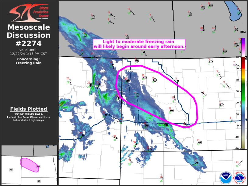
   Areas affected...Northwest to central North Dakota into far
   northeast Montana

   Concerning...Freezing rain

   Valid 221513Z - 221915Z

   SUMMARY...Light to moderate freezing rain (with rates possibly as
   high as 0.1 inch/hour) is expected to begin across far northeast
   Montana and into northwest North Dakota by early afternoon.

   DISCUSSION...Regional radar mosaics show light to moderate
   precipitation overspreading much of eastern MT, gradually moving
   east into ND within the left-exit region of a modest mid-level jet.
   12 UTC soundings from GGW and BIS show a pronounced 8-9 C warm nose
   between 900 to 850 mb with sub-freezing temperatures at the surface
   (including an impressive 22 C inversion on the BIS sounding). While
   some modulation of the low-level inversion is expected through early
   afternoon via wet-bulb cooling within the warm nose and downward
   mixing of warmer air near the surface, forecast guidance and recent
   surface obs suggest that most locations across northwest to central
   ND will maintain favorable low-level thermal profiles for freezing
   rain through much of the day.

   Live web cams from Williston and Dickinson, ND show little in the
   way of ongoing precipitation as of 15 UTC, suggesting that the
   initial wave of light precipitation currently moving over western ND
   is mainly saturating a dry 850-500 mb layer. This gradual saturation
   will promote steadier precipitation through early/mid-afternoon as
   additional showers migrate east from MT in tandem with the upper
   wave/jet. As such, the potential for freezing rain is expected to
   increase heading into the afternoon hours. Morning guidance suggests
   freezing rain rates up to 0.03 inch/hour are likely, but more
   aggressive solutions (notably the HRRR) hint that higher rates up to
   0.1 inch/hour are possible (though not probable given relatively
   weak mesoscale forcing for ascent).

   ..Moore.. 12/22/2024

   ...Please see www.spc.noaa.gov for graphic product...

   ATTN...WFO...BIS...GGW...

   LAT...LON   48530222 47930087 47690052 47470038 47010035 46830046
               46730079 46740107 46870167 47170261 47440340 47540373
               47720412 48060434 48440428 48580419 48730381 48760310
               48530222
|
|
|
Top/All Mesoscale Discussions/Forecast Products/Home |
|


