|
|
| Mesoscale Discussion 2270 | |
| < Previous MD | |

|
|
   Mesoscale Discussion 2270
   NWS Storm Prediction Center Norman OK
   1042 AM CST Mon Dec 16 2024

   Areas affected...from northeast Arkansas across the Missouri
   Bootheel and toward the Ohio River

   Concerning...Severe potential...Watch unlikely

   Valid 161642Z - 161915Z

   Probability of Watch Issuance...5 percent

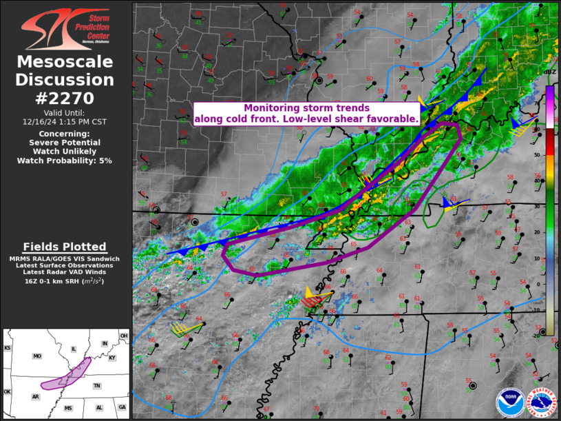
   SUMMARY...We are monitoring convective trends along the immediate
   cold front from far northeast Arkansas into western Kentucky.

   DISCUSSION...A cold front currently extends from southwest IN toward
   the MO Bootheel and into northern AR, with higher reflectivities
   within a currently low-topped convective line. Southwest surface
   winds continue to slowly bring relative warmth northward, with
   minimal instability currently. VWPs show 0-1 km SRH of 200-300
   m2/s2, with the strongest values over northern areas.

   Lightning activity as well as higher echo tops currently exist over
   northern AR and into the MO Bootheel where instability is more
   favorable. With time, gradual destabilization within the narrow
   pre-frontal zone, combined with low-level convergence, could result
   in a marginal severe risk. This risk is clearly conditional, but a
   small overlapping area of sufficient instability and favorable
   low-level shear cold result in a brief/weak tornado or localized
   damaging wind threat. At this time, a watch it not anticipated.

   ..Jewell/Gleason.. 12/16/2024

   ...Please see www.spc.noaa.gov for graphic product...

   ATTN...WFO...PAH...MEG...LZK...

   LAT...LON   37688814 37898778 37868748 37658743 37118787 36598831
               36028920 35798997 35579128 35659172 35889192 36059185
               36329062 36588976 37328860 37688814
|
|
|
Top/All Mesoscale Discussions/Forecast Products/Home |
|


