|
|
| Mesoscale Discussion 2265 | |
| < Previous MD | |

|
|
   Mesoscale Discussion 2265
   NWS Storm Prediction Center Norman OK
   0752 PM CST Thu Dec 12 2024

   Areas affected...portions of western NY State and Lake Erie Coast

   Concerning...Heavy snow

   Valid 130152Z - 130545Z

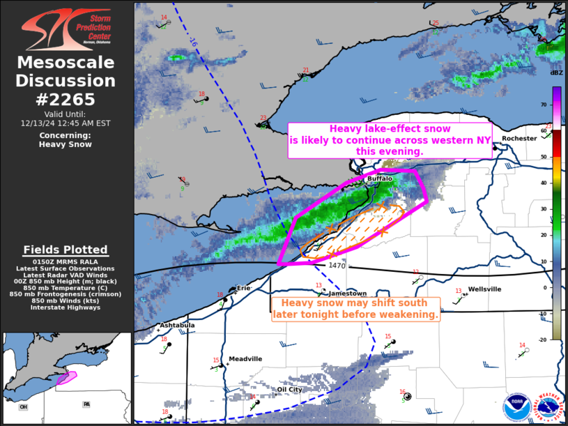
   SUMMARY...Heavy lake-effect snow is likely to continue for a few
   more hours across parts of western NY downstream from lake Erie. The
   heaviest snow rates ~ 2-3 in/hr are expected before 4z before the
   band begins to weaken and shift south.

   DISCUSSION...As of 0145Z, composite radar imagery shows a
   well-developed band of heavy lake-effect snow ongoing across
   portions of western NY downstream from Lake Erie. After slight
   weakening earlier this afternoon, a notable uptick in reflectivity
   and band organization has been noted this evening. The axis of
   heaviest snow has shifted north with rates of 1-3 in/hr moving into
   the southern suburbs of BUF. This should continue for a a few more
   hours this evening as flow in the lowest 2-3 km remains
   west/southwesterly as observed from the 00Z KBUF RAOB. Peak snowfall
   rates of 2-3 in/hr are likely in the next 1-2 hours while low-level
   flow is best aligned with the lake fetch and remains fairly strong.

   Snowfall rates will begin to decrease later this evening and
   overnight as the stronger westerly flow weakens with the departing
   upper cyclone over the Canadian Maritimes. As this occurs, low-level
   winds are also expected to veer to northwesterly, supporting a
   southward shift in the band as it weakens. While lake-effect snow
   showers are likely to continue through the overnight, snowfall rates
   should decrease below 1 in/hr after 6-8z.

   ..Lyons.. 12/13/2024

   ...Please see www.spc.noaa.gov for graphic product...

   ATTN...WFO...BUF...

   LAT...LON   42887906 42977873 42967841 42857834 42767830 42457896
               42347938 42327960 42327968 42657953 42887906
|
|
|
Top/All Mesoscale Discussions/Forecast Products/Home |
|


