|
|
| Mesoscale Discussion 2246 | |
| < Previous MD | |

|
|
   Mesoscale Discussion 2246
   NWS Storm Prediction Center Norman OK
   0916 AM CST Sat Nov 30 2024

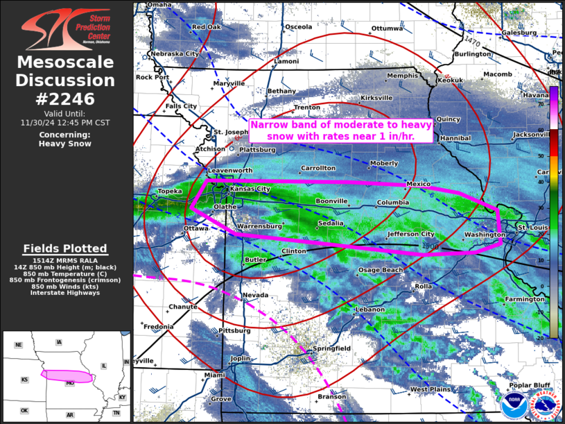
   Areas affected...the I-70 corridor in MO

   Concerning...Heavy snow

   Valid 301516Z - 301845Z

   SUMMARY...A narrow band of moderate to heavy snow should produce
   rates near 1 in/hr as it shifts east along the I-70 corridor from
   the Kansas City towards the St. Louis Metro Areas into early
   afternoon.

   DISCUSSION...Multiple bands have recently consolidated into a
   higher-reflectivity singular band along the I-70 corridor in eastern
   KS to western MO. This has impacted the Topeka to Kansas City Metro
   Areas with heavy snow being reported in the 15Z obs at TOP and MKC.
   Along the leading edge of the 35-dBZ reflectivity, enhanced KDP
   values of 0.6-0.7 deg/km have been coincident with the dendritic
   layer aloft, indicative of rates around 1 in/hr. While 12Z models
   (outside of the RAP) have signaled lesser snowfall rates relative to
   00Z guidance, the 00Z WRF-NSSL had a decent representation of the
   band, albeit a few hours too slow. It appears this band will
   probably continue eastward along the I-70 corridor towards the St.
   Louis Metro Area into early afternoon.

   ..Grams.. 11/30/2024

   ...Please see www.spc.noaa.gov for graphic product...

   ATTN...WFO...LSX...SGF...EAX...TOP...

   LAT...LON   39259491 39259273 39209163 39119105 38899047 38509044
               38399081 38389161 38519314 38629445 38919513 39259491
|
|
|
Top/All Mesoscale Discussions/Forecast Products/Home |
|


