|
|
| Mesoscale Discussion 2229 | |
| < Previous MD | |

|
|
   Mesoscale Discussion 2229
   NWS Storm Prediction Center Norman OK
   0125 AM CST Mon Nov 18 2024

   Areas affected...much of northwestern Texas into southwestern
   Oklahoma

   Concerning...Severe potential...Watch likely

   Valid 180725Z - 180930Z

   Probability of Watch Issuance...80 percent

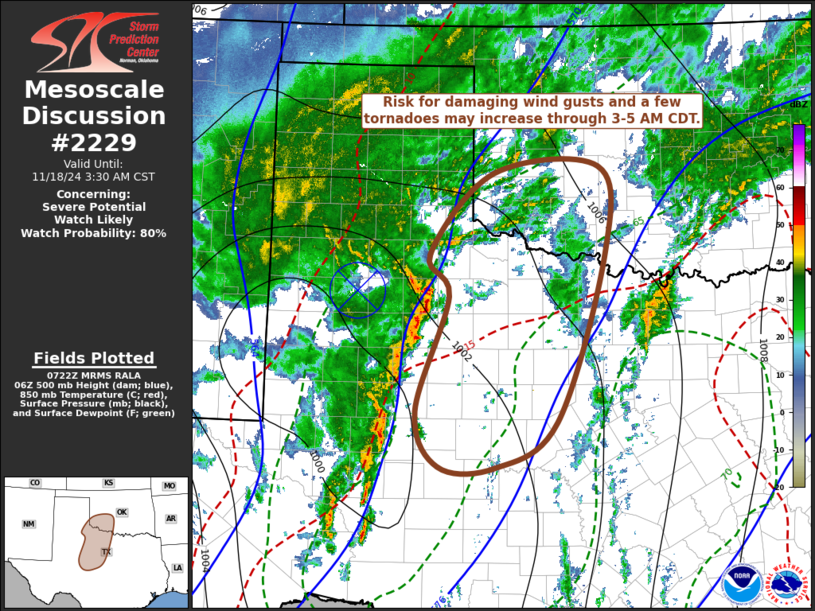
   SUMMARY...Potential for damaging wind gusts and perhaps a few
   tornadoes may begin to increase with an evolving squall line
   accelerating northeast of the Texas South Plains through much of
   northwestern Texas and southwestern Oklahoma by 3-5 AM CDT.

   DISCUSSION...Downstream of a 90+ kt 500 mb jet streak beginning to
   nose northeast of the Texas Big Bend into the Pecos Valley, strong
   forcing for ascent continues to aid the evolution of a squall line
   in advance of a deepening surface low now near/southwest of Lubbock.
   Instability is still rather weak in the presence of thermodynamic
   profiles characterized by modest mid-level lapse rates, but weak
   low-level lapse rates and modest moisture.  However, low-level and
   deep-layer shear is strong, and an ill-defined meso-beta scale
   mid-level cyclonic circulation is now progressing  northeast of
   Lubbock.

   A number of better defined meso-gamma scale cyclonic circulations
   are evident along the line, which has been surging northeastward
   around 30 kt, to the northeast of the mid-level circulation.  This
   appears likely to propagate into the Altus OK vicinity through
   09-11Z, with the southern flank of the line progressing across the
   Abilene TX vicinity.

   In response to the deepening surface troughing, a gradual
   north-northwestward advection of mid 60s to near 70F surface dew
   points toward the upstream squall line will gradually contribute to
   somewhat more unstable updraft inflow.  This may also contribute to
   a boundary-layer at least marginally more supportive of downward
   momentum transfer to the surface and potential for tornadoes, as
   low-level shear intensifies beneath an 850 mb jet forecast to
   strengthen in excess of 50 kt.

   ..Kerr/Gleason.. 11/18/2024

   ...Please see www.spc.noaa.gov for graphic product...

   ATTN...WFO...FWD...OUN...SJT...LUB...AMA...MAF...

   LAT...LON   33610035 34130064 35169968 35239810 34159800 32049873
               31479966 31470050 32160084 33610035
|
|
|
Top/All Mesoscale Discussions/Forecast Products/Home |
|
Source link


