|
|
| Mesoscale Discussion 2226 | |
| < Previous MD | |

|
|
   Mesoscale Discussion 2226
   NWS Storm Prediction Center Norman OK
   0806 PM CST Wed Nov 13 2024

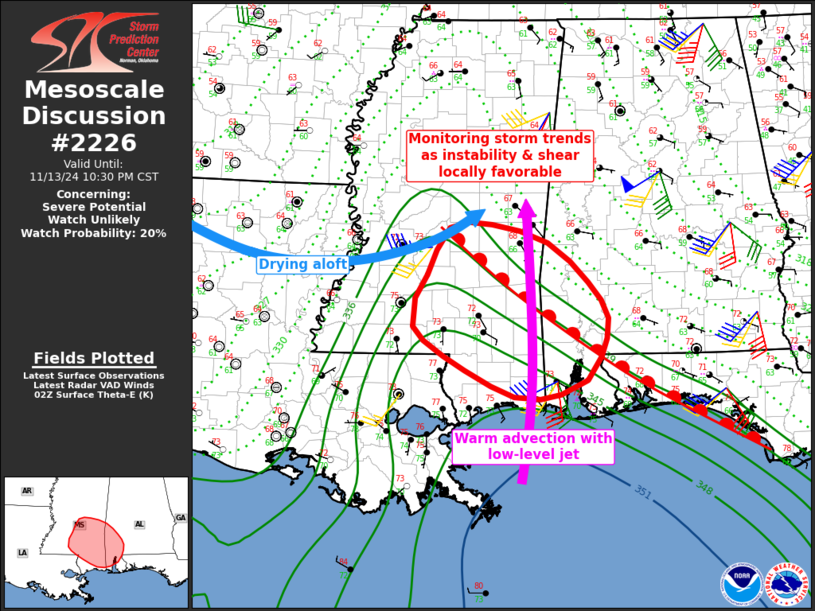
   Areas affected...much of southern Mississippi into southwest Alabama

   Concerning...Severe potential...Watch unlikely

   Valid 140206Z - 140430Z

   Probability of Watch Issuance...20 percent

   SUMMARY...An isolated severe storm cannot be ruled out near the warm
   front from southern Mississippi into southwest Alabama through late
   evening. A brief tornado or damaging gust would be possible.

   DISCUSSION...A northeast/southwest oriented line of thunderstorms
   currently extends from northwest AL and northern MS into far eastern
   LA, with indications of stronger activity along the cold front and
   approaching the warm front. This warm front separates the robust
   moisture to the south with 70s F dewpoints, while north of there
   into east-central MS and much of central AL, temperatures are cool
   and in the 60s.

   Meanwhile, southerly winds around 850 mb over 40 kt are forecast
   through evening, which may yield some northward advancement of the
   warm front. Low-level shear in this vicinity will also favor
   rotation given a strong enough storm, with effective SRH of several
   hundred m2/s2.

   As such, the area will be monitored for additional development over
   the warm sector, which could potentially interact with the higher
   shear zone along and south of the warm front.

   ..Jewell/Hart.. 11/14/2024

   ...Please see www.spc.noaa.gov for graphic product...

   ATTN...WFO...BMX...MOB...JAN...LIX...

   LAT...LON   31428752 30968762 30698781 30518817 30498882 30978981
               31329023 31679021 31959004 32518972 32548913 32338835
               31868779 31428752
|
|
|
Top/All Mesoscale Discussions/Forecast Products/Home |
|


