|
|
| Mesoscale Discussion 2221 | |
| < Previous MD | |

|
|
   Mesoscale Discussion 2221
   NWS Storm Prediction Center Norman OK
   0151 PM CST Fri Nov 08 2024

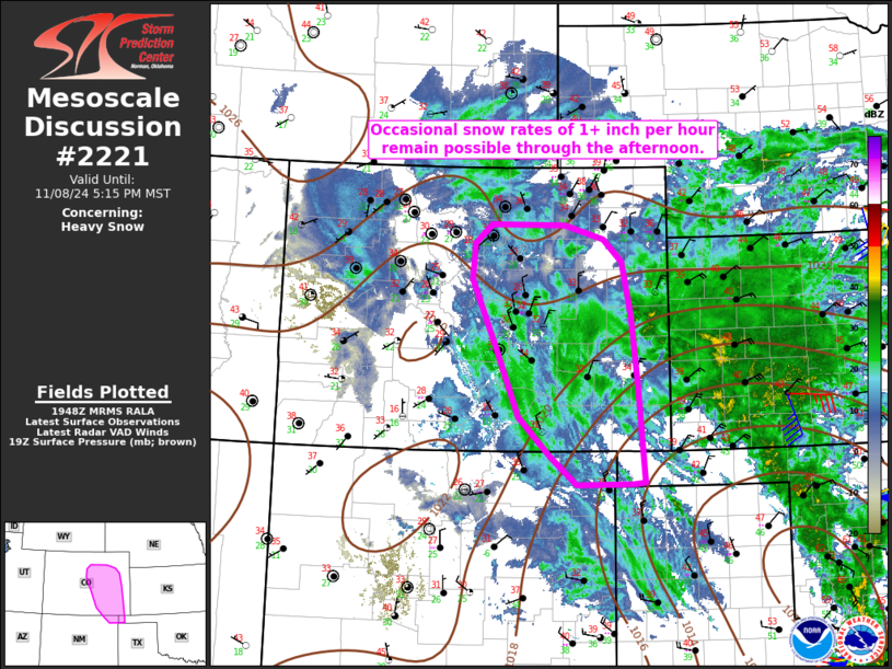
   Areas affected...Parts of eastern CO into extreme northeast NM and
   the western OK Panhandle

   Concerning...Heavy snow

   Valid 081951Z - 090015Z

   SUMMARY...Occasional snow rates of 1+ inch per hour will be possible
   through the afternoon.

   DISCUSSION...The deep mid/upper-level cyclone over NM that is
   supporting the ongoing long-duration snow event is currently in the
   process of pivoting north-northeastward, with a weak but deepening
   surface low moving northward near the OK/TX Panhandle border, where
   2-hour pressure falls of 2-3 mb have been noted. Some continued
   deepening of this system is possible through the afternoon, which
   will maintain favorable deep ascent across eastern CO and vicinity.

   Persistent low-level moisture transport and ascent attendant to the
   cyclone could lead to some increase in snow rates this afternoon
   across parts of eastern CO, as precipitation pivots northwestward to
   the north of the low. While low-level temperatures will remain
   rather marginal, precipitation may become heavy enough to support
   occasional snow rates of 1+ inches per hour through the afternoon.

   ..Dean.. 11/08/2024

   ...Please see www.spc.noaa.gov for graphic product...

   ATTN...WFO...GLD...AMA...PUB...BOU...ABQ...

   LAT...LON   36520370 36910417 37480474 38490517 39410558 39920555
               40190523 40190392 39980321 39670288 38910272 37940261
               36540249 36530270 36520370
|
|
|
Top/All Mesoscale Discussions/Forecast Products/Home |
|


