|
|
| Mesoscale Discussion 2210 | |
| < Previous MD | |

|
|
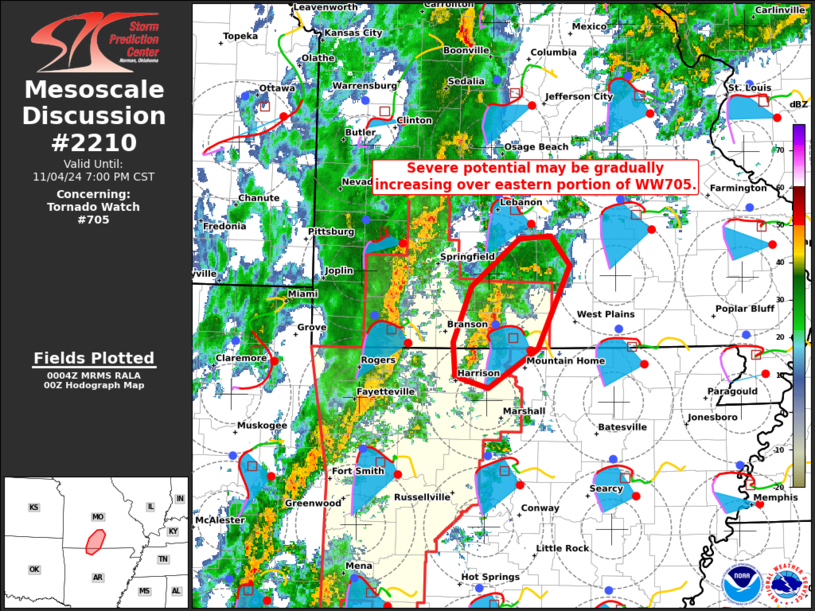
Mesoscale Discussion 2210 NWS Storm Prediction Center Norman OK 0607 PM CST Mon Nov 04 2024 Areas affected...North-central Arkansas into south-central Missouri Concerning...Tornado Watch 705... Valid 050007Z - 050100Z The severe weather threat for Tornado Watch 705 continues. SUMMARY...Severe potential, including the risk of a tornado or two, may be increasing over portions of north-central AR into south-central MO -- on the eastern edge of Tornado Watch 705. DISCUSSION...A cluster of thunderstorms out ahead of the main convective line has shown a recent uptick in intensity and organization over north-central AR into south-central MO. This may be in response to a strengthening low-level jet from the south (see LZK VWP) and associated surface pressure falls/increasing low-level confluence. Boundary-layer moisture is also increasing ahead of these storms (lower 70s dewpoints streaming northward), which should aid in intensification despite modest instability. Large clockwise-curved hodographs (around 400 m2/s2 effective SRH) will support embedded right-moving supercells with an associated tornado risk, and a strong tornado cannot be entirely ruled out given the ample boundary-layer streamwise vorticity. ..Weinman.. 11/05/2024 ...Please see www.spc.noaa.gov for graphic product... ATTN...WFO...LZK...SGF... LAT...LON 36559312 37029294 37429243 37449210 37209190 36499224 36159275 36269311 36559312 |
|
|
Top/All Mesoscale Discussions/Forecast Products/Home |
|
Source link


