|
|
| Mesoscale Discussion 2205 | |
| < Previous MD Next MD > | |

|
|
   Mesoscale Discussion 2205
   NWS Storm Prediction Center Norman OK
   0114 PM CST Mon Nov 04 2024

   Areas affected...northeast Oklahoma...southeast Kansas...Southwest
   Missouri and far northern Arkansas.

   Concerning...Severe potential...Watch likely

   Valid 041914Z - 042045Z

   Probability of Watch Issuance...80 percent

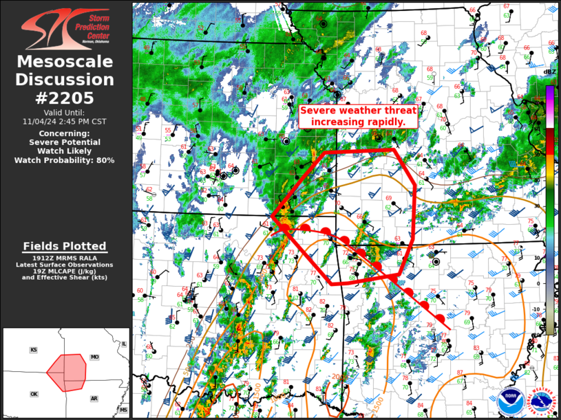
   SUMMARY...The severe weather threat is increasing rapidly across
   southeast Kansas, southwest Missouri, and far northwest Arkansas.

   DISCUSSION...Surface analysis shows a warm front advancing northeast
   across eastern Oklahoma to near the Oklahoma/Kansas border and far
   southern Missouri. A line embedded supercell with a confirmed
   tornado is moving through northeast Oklahoma and should persist
   northeast through the afternoon/evening. The area where the line of
   storms interacts with the warm front will likely continue to be a
   favorable location for tornado development. In addition, any mature
   supercells which develop ahead of the line could also pose a tornado
   threat given the favorable low-level shear profile which is expected
   to improve through the evening.

   ..Bentley/Hart.. 11/04/2024

   ...Please see www.spc.noaa.gov for graphic product...

   ATTN...WFO...LZK...SGF...EAX...TSA...ICT...

   LAT...LON   36989600 37689533 38109487 38159334 37539289 36609296
               35999325 35839435 35829471 36989600
|
|
|
Top/All Mesoscale Discussions/Forecast Products/Home |
|


