|
|
| Mesoscale Discussion 2206 | |
| < Previous MD | |

|
|
   Mesoscale Discussion 2206
   NWS Storm Prediction Center Norman OK
   0126 PM CST Mon Nov 04 2024

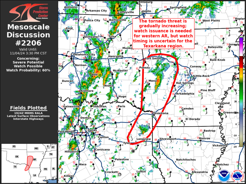
   Areas affected...The Texarkana region into western Arkansas

   Concerning...Severe potential...Watch possible

   Valid 041926Z - 042130Z

   Probability of Watch Issuance...60 percent

   SUMMARY...The severe/tornado threat appears to be gradually
   increasing from the Texarkana region into western Arkansas. Watch
   issuance is expected for western AR, but timing remains uncertain
   due to questions regarding short-term storm coverage across the
   Texarkana region.

   DISCUSSION...Radar imagery out of KFSM and KSHV has shown a few
   deeper/more robust thunderstorms beginning to develop with transient
   mid to low-level mesocyclones across the Texarkana region and across
   parts of western AR. Stable billow clouds noted earlier in satellite
   imagery have begun to erode as daytime heating and a lifting warm
   front promote steady destabilization (MLCAPE up to around 1500 J/kg
   per mesoanalysis estimates), suggesting that convection is gradually
   becoming rooted near the surface. Additionally, the KFSM VWP is
   sampling 0-1 km SRH between 150-180 m2/s2, which is adequate to
   support a tornado threat with discrete convection. Watch issuance is
   expected for portions of western AR where convective trends and
   recent high-res guidance suggests a severe/tornado threat is
   developing. Further south, weaker forcing for ascent casts some
   doubt on thunderstorm coverage for the short term and when watch
   issuance will be needed this afternoon/evening (though trends will
   continue to be monitored).

   ..Moore/Hart.. 11/04/2024

   ...Please see www.spc.noaa.gov for graphic product...

   ATTN...WFO...LZK...SHV...TSA...

   LAT...LON   32639509 33609451 34639445 35179445 35449436 35589409
               35619368 35569329 35459303 35299295 35059293 34649309
               34099330 33459366 32969398 32709418 32519441 32429467
               32399487 32419502 32639509
|
|
|
Top/All Mesoscale Discussions/Forecast Products/Home |
|
Source link


