|
|
| Mesoscale Discussion 2203 | |
| < Previous MD | |

|
|
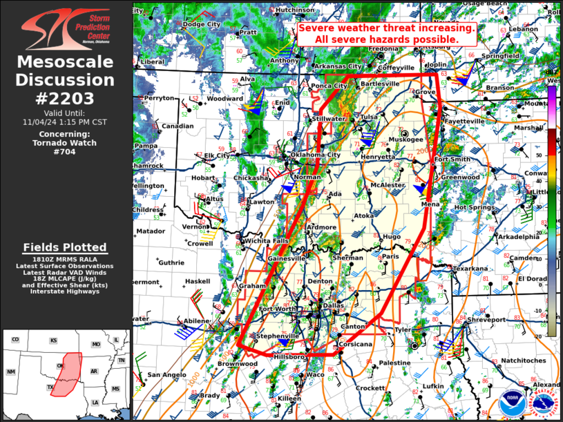
Mesoscale Discussion 2203 NWS Storm Prediction Center Norman OK 1212 PM CST Mon Nov 04 2024 Areas affected...eastern Oklahoma and north-central Texas Concerning...Tornado Watch 704... Valid 041812Z - 041915Z The severe weather threat for Tornado Watch 704 continues. SUMMARY...The severe weather threat is increasing across north-central Texas and eastern Oklahoma. DISCUSSION...A line of storms has developed east of I-35 in central Oklahoma and is slowly drifting east. These storms are showing some sign of severe intensity and occasional rotation, but they are struggling to move ahead of the boundary. However, visible satellite is showing signs of some development ahead of the boundary across north Texas and eastern Oklahoma. This development will likely pose a greater severe weather threat with supercells capable of large hail, severe wind and several tornadoes (some which may be strong) through the afternoon hours. Currently, flow is southerly or south-southwesterly across the warm sector, but is expected to back to 160-170 by later this afternoon with the deepening cyclone and a strengthening low-level jet. Therefore, the greatest tornado threat will be with any discrete supercells after 21Z across eastern Oklahoma and north Texas. ..Bentley/Hart.. 11/04/2024 ...Please see www.spc.noaa.gov for graphic product... ATTN...WFO...SGF...SHV...TSA...FWD...OUN... LAT...LON 32139854 34659721 35369692 36379685 36969624 36999428 36409421 34239461 32729554 31999655 31979794 32139854 |
|
|
Top/All Mesoscale Discussions/Forecast Products/Home |
|
Source link


