|
|
| Mesoscale Discussion 2202 | |
| < Previous MD | |

|
|
   Mesoscale Discussion 2202
   NWS Storm Prediction Center Norman OK
   0837 AM CST Mon Nov 04 2024

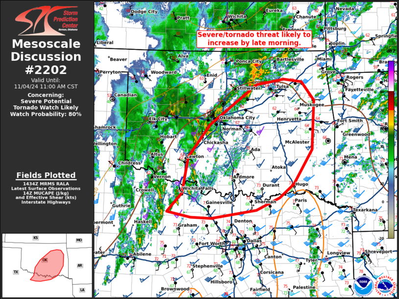
   Areas affected...central/eastern Oklahoma and north Texas

   Concerning...Severe potential...Tornado Watch likely

   Valid 041437Z - 041700Z

   Probability of Watch Issuance...80 percent

   SUMMARY...The severe/tornado threat is likely to increase by late
   morning.

   DISCUSSION...A very moist airmass is present from north Texas to
   much of eastern Oklahoma with dewpoints in the upper 60s. This has
   already yielded 1000 to 1500 J/kg MLCAPE with minimal surface
   heating. Given the minimal inhibition (per SPC mesoanalysis and
   regional 12Z RAOBs), expect widespread thunderstorm development by
   late morning to early afternoon. Moderate instability and strong
   shear will support supercells capable of all hazards. Parts of
   central and south-central Oklahoma (near the I-35 corridor) have the
   greatest uncertainty. Outflow from this mornings storms has advanced
   east of I-35 with low 60s dewpoints and northerly/westerly flow.
   However, strong, southerly flow is trying to stall this boundary and
   lead to northward/westward airmass recovery within this corridor.

   A tornado watch will eventually be needed, but it is unclear whether
   the threat will start to increase in the next 1 to 2 hours or closer
   to mid-day when the primary ascent overspreads the region. Trends
   will be monitored and a watch will be issued when an organized
   severe threat appears imminent.

   ..Bentley/Hart.. 11/04/2024

   ...Please see www.spc.noaa.gov for graphic product...

   ATTN...WFO...TSA...FWD...OUN...

   LAT...LON   33889847 34679833 35399776 36279652 36399579 36329531
               35929498 34839505 34099554 33789591 33519652 33349771
               33369825 33489886 33889847
|
|
|
Top/All Mesoscale Discussions/Forecast Products/Home |
|


