|
|
| Mesoscale Discussion 2201 | |
| < Previous MD | |

|
|
   Mesoscale Discussion 2201
   NWS Storm Prediction Center Norman OK
   0501 AM CST Mon Nov 04 2024

   Areas affected...Northwest TX...Southwest/South-Central/Central OK

   Concerning...Severe potential...Watch possible

   Valid 041101Z - 041300Z

   Probability of Watch Issuance...60 percent

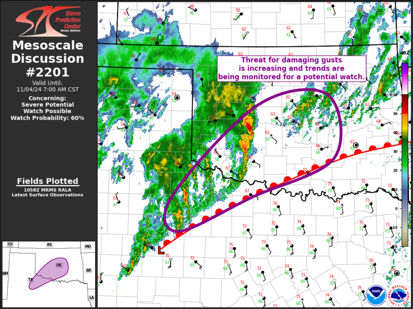
   SUMMARY...Threat for damaging gusts is increasing across central
   Oklahoma, with some increase in the threat across southwest Oklahoma
   and adjacent far northwest Texas as well. Trends are being monitored
   for a possible watch.

   DISCUSSION...Recent surface analysis places a low between SNK and
   SWW in the Low Rolling Plains region of TX. A warm front extends
   northeastward from this low through northwest TX and south-central
   OK into southeast OK. Location of this front is roughly demarcated
   by the 70 deg F isotherm. Showers and thunderstorms are currently
   ongoing north of this boundary from far northwest TX into southwest
   OK, supported by both low-level warm-air advection and increasing
   large-scale ascent (attendant to the approaching shortwave trough).
   A few of the cells over west-central/southwest OK have become better
   organized over the past hour or so, with the cell in Tillman County
   exhibiting a notable forward surge while also producing a 55 kt gust
   at FDR. The threat for damaging gusts will continue with this
   developing line as it continues northeastward into central OK. The
   tornado threat should be limited by the low buoyancy and persisting
   modest convective inhibition. That being said, if this line is able
   to become surface-based, or even near-surface-based, there is enough
   low-level shear to promote circulations embedded within the line.

   While not evident at the moment, a similar evolution, where the
   elevated storms become organized into a more coherent line, is also
   possible farther south across far northwest TX. Overall convective
   trends will be monitored for a potential watch or watches across
   this region.

   ..Mosier/Edwards.. 11/04/2024

   ...Please see www.spc.noaa.gov for graphic product...

   ATTN...WFO...TSA...OUN...SJT...LUB...

   LAT...LON   33060030 33800046 35769829 35969648 34619633 33819842
               33060030
|
|
|
Top/All Mesoscale Discussions/Forecast Products/Home |
|


