|
|
| Mesoscale Discussion 2193 | |
| < Previous MD | |

|
|
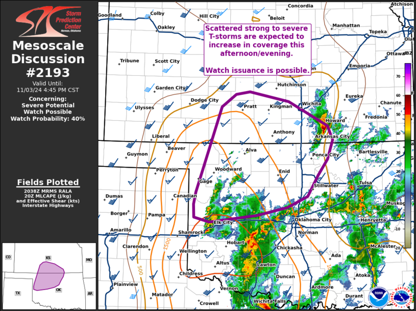
   Mesoscale Discussion 2193
   NWS Storm Prediction Center Norman OK
   0240 PM CST Sun Nov 03 2024

   Areas affected...Northwest Oklahoma into south-central Kansas

   Concerning...Severe potential...Watch possible

   Valid 032040Z - 032245Z

   Probability of Watch Issuance...40 percent

   SUMMARY...Thunderstorms will increase in coverage through the late
   afternoon and evening hours. Scattered strong to severe storms are
   expected and will pose a risk of large hail, damaging winds, and
   perhaps a tornado. Trends will be monitored for the need for a watch
   later this evening.

   DISCUSSION...Over the past hour, convection has increased in
   coverage across western OK along the I-40 corridor in response to
   strengthening low-level warm advection and steady destabilization.
   MRMS VII and cloud top temperature trends suggest that much of the
   activity along and north of I-40 remains sub-severe, but signs of
   intensification have been noted in a few cells. The expectation is
   thunderstorm coverage will continue to increase as this activity
   spreads from western OK into northwest OK and south-central KS
   through the late afternoon and evening hours. While most convection
   will likely remain elevated, steady warming/moistening in the low
   levels may support a few surface based storms - especially where
   temperatures and dewpoints can reach into the low 70s and upper 60s
   respectively. 40-60 knot mid and upper-level flow over the region is
   supporting elongated hodographs favorable for supercells with an
   attendant risk for large hail (most likely between 1.0-1.75 inches)
   and severe wind gusts. Additionally, the low-level warm advection
   regime is yielding 0-1 km SRH values between 200-300 m2/s2 (per
   regional VWPs), which will support a tornado threat if surface-based
   convection can be realized. While this potential is noted, weak
   inhibition and persistent ascent will promote scattered
   thunderstorms with a somewhat high probability for storm
   interactions and unfavorable storm modes as storms spread
   north/northeast with time. Trends will be monitored for the need for
   watch issuance if semi-discrete, surface-based convection can be
   realized and pose a greater severe threat.

   ..Moore/Hart.. 11/03/2024

   ...Please see www.spc.noaa.gov for graphic product...

   ATTN...WFO...TSA...ICT...OUN...DDC...

   LAT...LON   35839987 36069983 37699922 37949889 37999855 37809763
               37329671 37059659 36699672 36379694 35989720 35779767
               35619840 35489951 35589987 35839987
|
|
|
Top/All Mesoscale Discussions/Forecast Products/Home |
|


