|
|
| Mesoscale Discussion 2191 | |
| < Previous MD | |

|
|
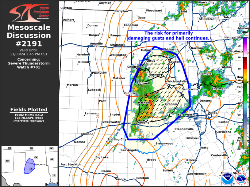
Mesoscale Discussion 2191 NWS Storm Prediction Center Norman OK 0113 PM CST Sun Nov 03 2024 Areas affected...western North Texas and southwest Oklahoma Concerning...Severe Thunderstorm Watch 701... Valid 031913Z - 032045Z The severe weather threat for Severe Thunderstorm Watch 701 continues. SUMMARY...Severe storms continue to organize early this afternoon. The risk for damaging winds, hail and a tornado or two should increase as storms grow upscale. DISCUSSION...Across WW701, intermittent heating amidst strong low-level warm air advection has resulted in several clusters of strong to severe storms across portions of western North TX. Within an unstable and moderately sheared environment, further intensification/development of new storms is expected this afternoon and evening across portions of northwest TX and southwest OK. Storm mode has been mixed with predominately linear elements near I-20 and a few more cellular structures farther north. Hi-res guidance suggests the additional storms that develop will prompt upscale growth into one or more linear clusters or a QLCS with time. Storms should spread over much of western North TX and into southwestern Oklahoma later this afternoon and evening. The potential for numerous storm interactions and upscale growth suggests the primary severe risk over the next few hours will be wind and hail. However, shear profiles are strong enough to support supercells, and some guidance does show more discrete development is possible ahead of the primary band of storms. Should this occur, a risk for a few tornadoes could materialize near the warm front where low-level hodograph curvature is maximized. ..Lyons.. 11/03/2024 ...Please see www.spc.noaa.gov for graphic product... ATTN...WFO...FWD...OUN...SJT...LUB... LAT...LON 32320030 33929998 34879942 35239900 34959807 34589782 33899756 33119750 32609813 31969900 31929907 31920010 32320030 |
|
|
Top/All Mesoscale Discussions/Forecast Products/Home |
|


