|
|
| Mesoscale Discussion 2163 | |
| < Previous MD | |

|
|
   Mesoscale Discussion 2163
   NWS Storm Prediction Center Norman OK
   0115 PM CDT Wed Oct 30 2024

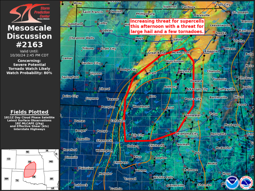
   Areas affected...Western/northern Oklahoma and southern Kansas

   Concerning...Severe potential...Tornado Watch likely

   Valid 301815Z - 301945Z

   Probability of Watch Issuance...80 percent

   SUMMARY...There is an increasing threat for supercells this
   afternoon across western/north-central Oklahoma and southern Kansas.
   These storms will have a threat for large hail and a few tornadoes.

   DISCUSSION...Some type of impulse triggered some elevated
   thunderstorms across southern Kansas this morning. In the wake of
   this activity, subsidence has resulted in clearing and significant
   surface heating across western Oklahoma and southern Kansas. In
   addition, low-level moisture advection has increased dewpoints to
   64-67F ahead of the dryline as far north as Reno and Harvey Counties
   in Kansas. SPC mesoanalysis currently suggests around 1000 to 1500
   J/kg MLCAPE and minimal inhibition. Continued surface heating and
   mid-level cooling may allow for some additional destabilization
   later this afternoon. Current visible satellite shows deepening
   cumulus along the dryline from Harper County, Oklahoma to near
   Childress, TX. Expect initial strong/severe storm development near
   the triple point in northwest Oklahoma/southern Kansas where forcing
   is strongest. Eventually expect additional development southward
   along the dryline to near I-40 in Oklahoma. These storms along the
   dryline will have greater potential to remain discrete for a few
   hours given the more favorable boundary orientation. At this time,
   the most favored solution is a more linear wind/QLCS tornado threat
   along the cold front in Kansas with a more discrete hail/strong
   tornado threat associated with supercells in northern Oklahoma and
   southern Kansas. Based on current trends, a tornado watch will
   likely be needed soon.

   ..Bentley/Gleason.. 10/30/2024

   ...Please see www.spc.noaa.gov for graphic product...

   ATTN...WFO...TSA...ICT...OUN...DDC...

   LAT...LON   36549670 35609744 35309849 35279969 35899975 36769972
               37569937 38359811 38599710 38119665 36549670
|
|
|
Top/All Mesoscale Discussions/Forecast Products/Home |
|
Source link


